CIG-Bench: A Comprehensive Survey and Benchmark for AI-Driven Subsurface Imaging Understanding
面向AI驱动地下成像理解的综合性综述与基准
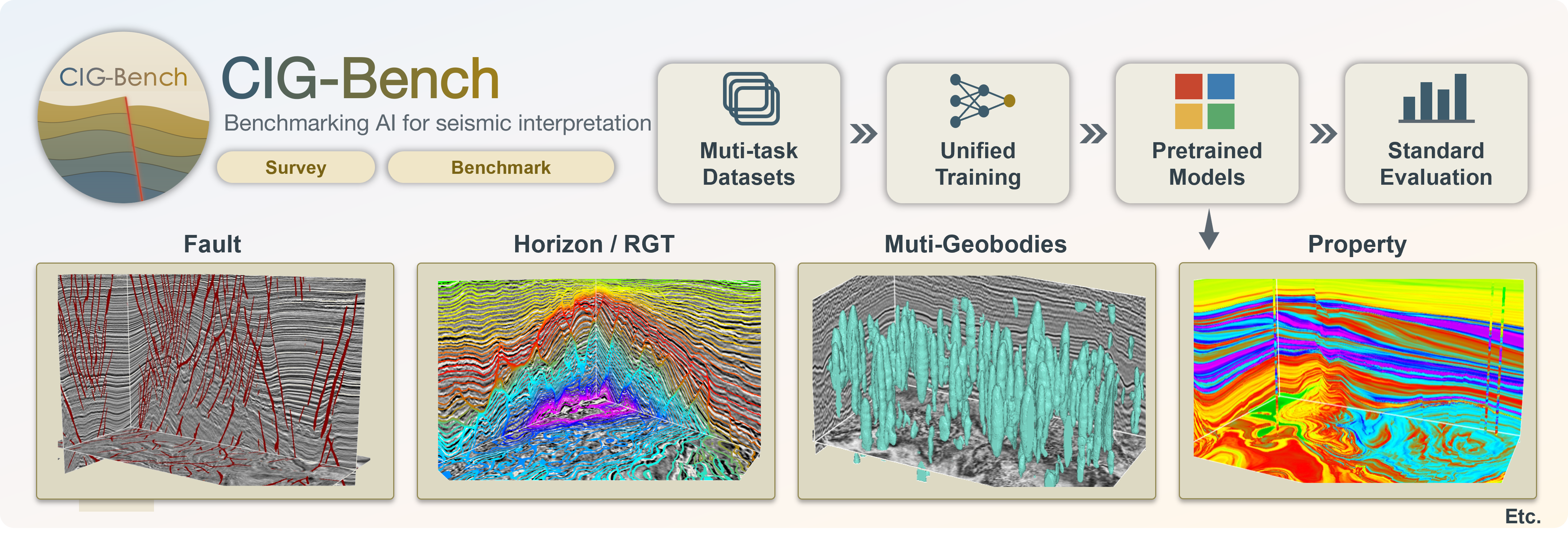
- We present CIG-Bench, a comprehensive survey and open benchmark for AI-driven subsurface imaging understanding. By systematically reviewing 652 publications from 2015 to 2025, we summarize the development of deep-learning methods for structural interpretation, geobody identification, seismic facies analysis, and property estimation. To enable reproducible research and fair comparison, CIG-Bench provides unified datasets, pretrained models, evaluation protocols, and easy-to-use tools for fault segmentation, relative geologic time estimation, geobody segmentation, and property modeling. CIG-Bench will be continuously updated as a community-oriented platform for advancing intelligent subsurface interpretation.
- Project page: https://cig.ustc.edu.cn/cigBench
- Dou Y., X. Wu*, H. Gao, M. Liu, T. Zhao, Z. Zhong, H. Di, M. J. Park, R. G. Clapp, Z. Guo, L. Han, and S. Fomel, 2026, CIG-Bench: A Comprehensive Survey and Benchmark for AI-Driven Subsurface Imaging Understanding, arXiv:2606.09094.
FA-Picker: Physics-Constrained Spatiotemporal Modeling for Real-Time First-Arrival Picking
面向阵列声波测井实时初至拾取的物理约束时空建模方法
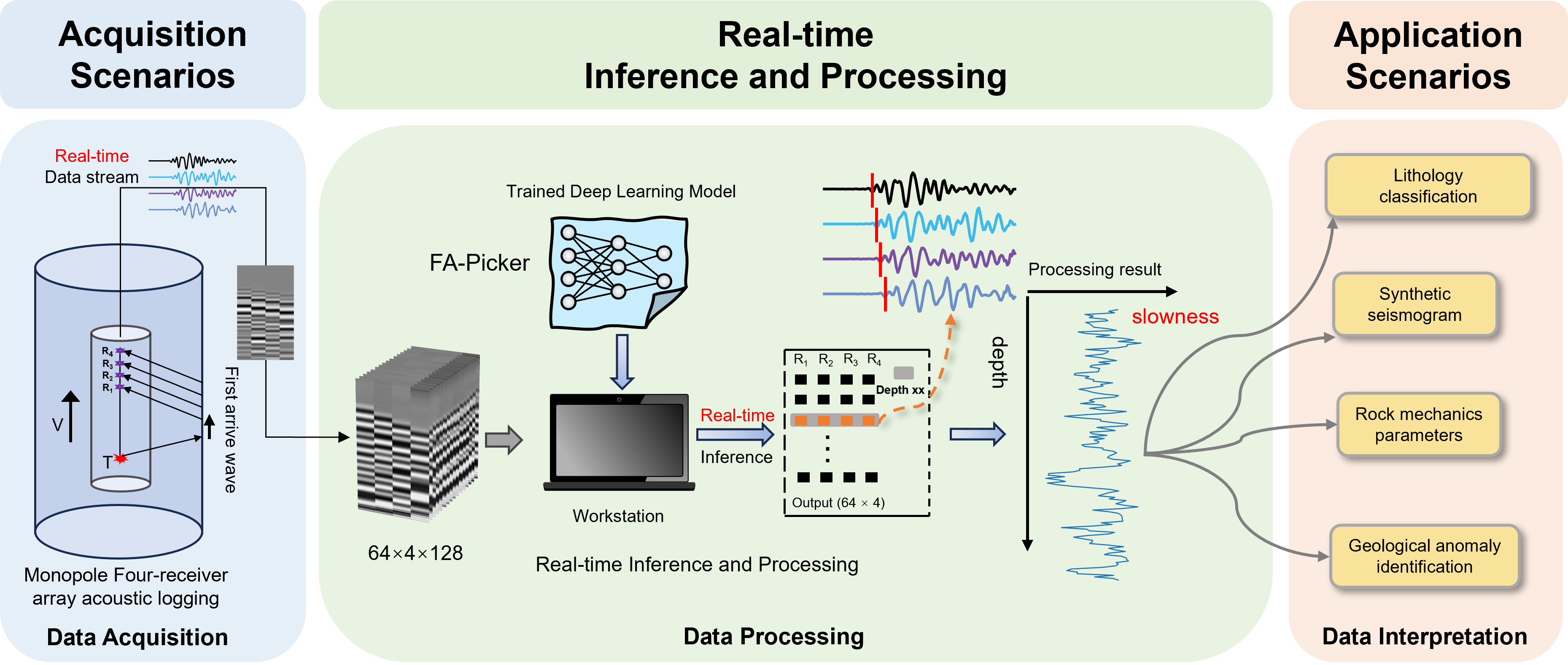
- We develop FA-Picker, a physics-constrained deep learning framework for accurate and real-time first-arrival picking from array acoustic logging data. By jointly modeling waveform variations across time, receivers, and consecutive depths, FA-Picker captures the inherent spatiotemporal structure of multichannel acoustic signals. Soft and hard physical constraints are further incorporated to ensure that the predicted arrival times comply with acoustic wave propagation laws. To address the scarcity of expert-labeled data, we also establish a physics-guided synthetic data generation workflow covering diverse formation and acquisition conditions. Tests on eight unseen field wells demonstrate strong accuracy, robustness, cross-well generalization, and real-time processing capability, providing an efficient solution for intelligent acoustic logging interpretation.
- Wang L., X. Wu*, Z. Sun, and Y. Dou, Physics-Constrained Spatiotemporal Modeling for Temporal Localization in Structured Multichannel Acoustic Signals, Pattern Recognition, in revision.
Objective-programmable implicit structural modeling under heterogeneous data and geological priors
多信息融合三维隐式构造建模
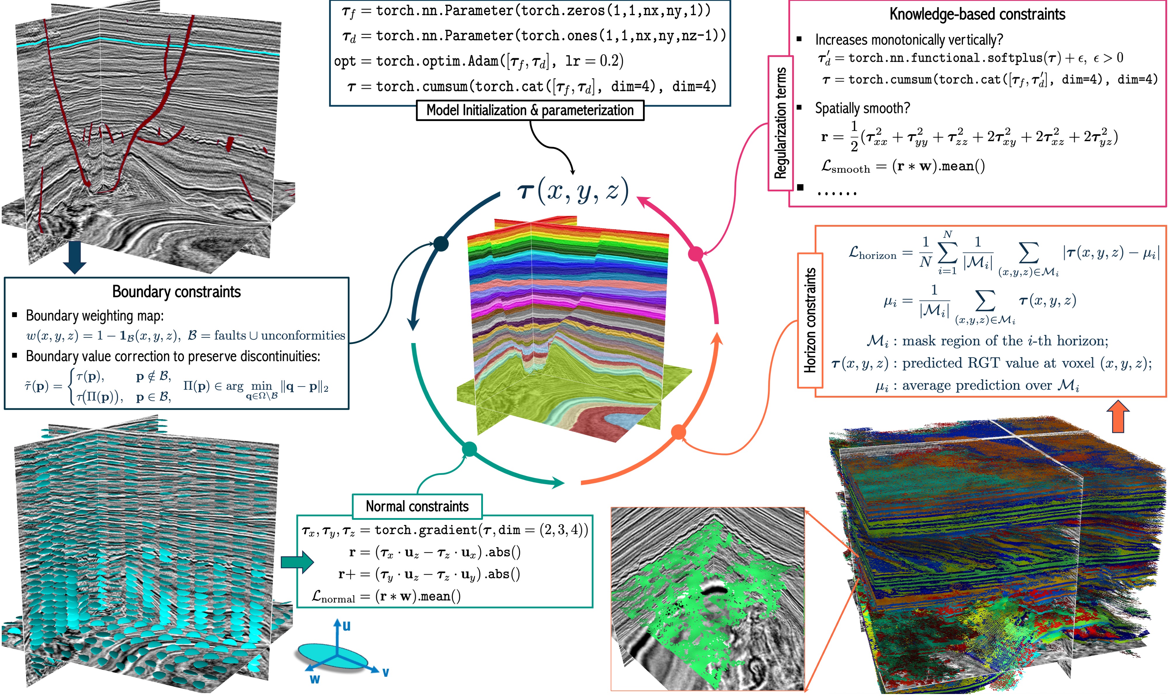
- We present an objective-programmable, differentiable inversion framework for 3D implicit structural modeling that fuses heterogeneous geoscience data under explicit, geology-informed constraints. Rather than training an amortized predictor, we treat the implicit structural field as the trainable parameter field and optimize it directly with PyTorch and automatic differentiation. This formulation makes composite objectives easy to express and minimize, including horizon-consistency within stratigraphic layers, normal-alignment with structure-guided directions, soft depth-monotonicity, Hessian-based smooth-where-possible regularization, and boundary preservation near faults and unconformities. Compared with conventional pipelines, our approach unifies data and geological priors within a single auditable, auto-differentiable program and avoids bespoke solvers as objectives and data types evolve. This work provides a scalable and extensible template for three-dimensional structural modeling and multi-source geological data integration.
- Wu, X., H. Gao, C. Yang, R. Yu, Z. Guo, and Y. Dou 2026, Objective-programmable implicit structural modeling under heterogeneous data and geological priors, submitted.
Implicit Structural Modeling via Generative Diffusion Framework
基于生成式扩散框架的隐式构造建模
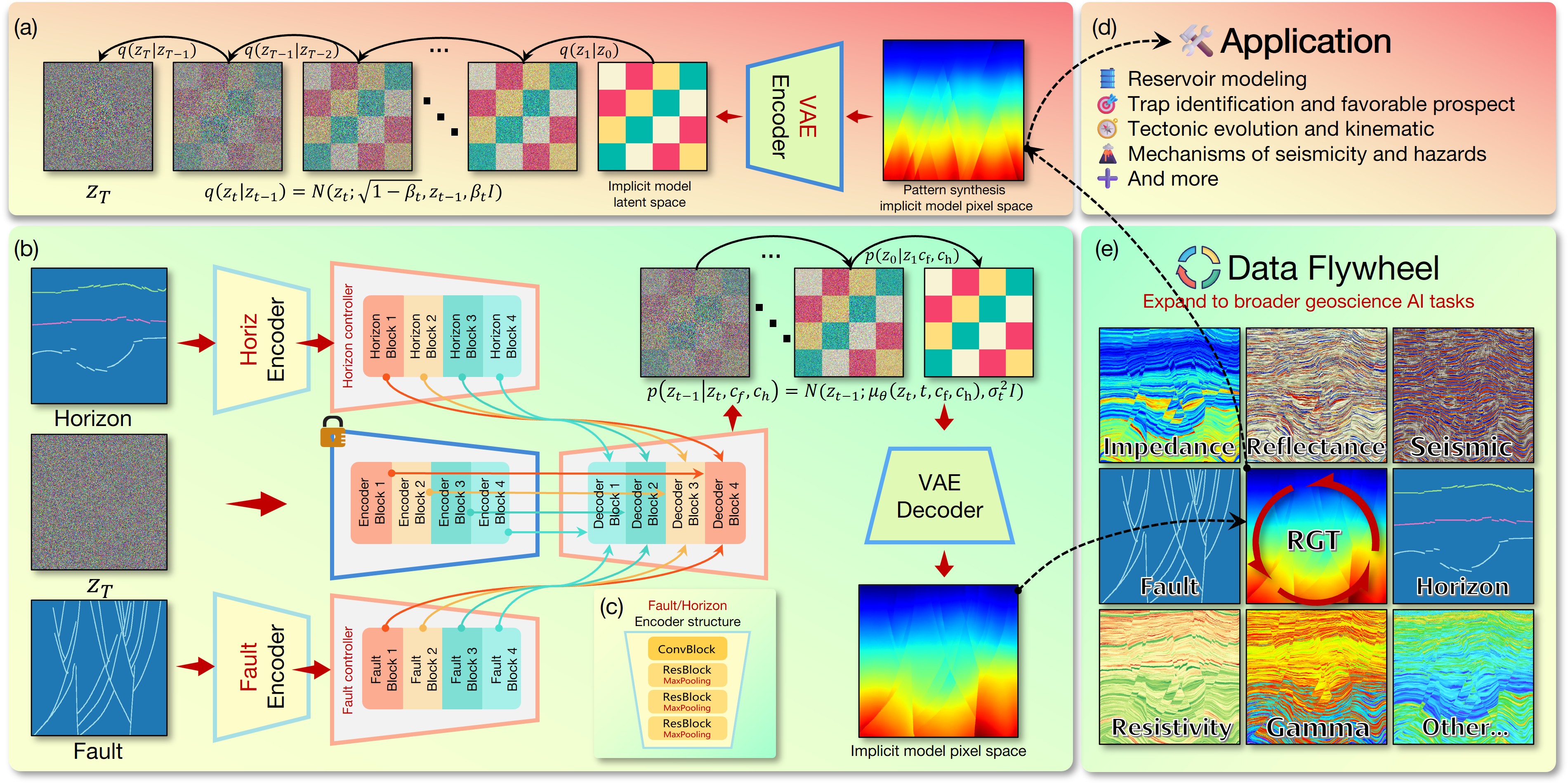
- We propose a diffusion based approach trained on synthetic examples from simulation. The model uses the available fault and horizon information as guidance during generation, which helps the constraints influence the result even in poorly constrained regions. Although trained on simplified normal faults, it generalizes to strike-slip and flower fault systems and remains stable in fold-thrust settings where layer order can change abruptly across detachments.
- Dou, Y., X. Wu*, Z. Guo, H. Gao, 2026, Implicit Structural Modeling via Generative Diffusion Framework, submitted.
Memory-Efficient Full-Volume Inference for Large-Scale 3D Dense Prediction without Performance Degradation
显存受限下全尺寸3D大数据体的CNN模型推理(简单有效,强烈推荐)
- Challenge: Deep learning models face difficulties in full-size 3D volumetric inference due to memory constraints and inefficient operator execution. Limitations of Conventional Solutions: Tiling/compression often cause artifacts, damage spatial consistency, or require retraining. Proposed Method: A retraining-free inference optimization framework enabling accurate, efficient whole-volume prediction without performance loss. Core Technologies: Integrates operator spatial tiling, operator fusion, normalization statistic aggregation, and on-demand feature recomputation (reduces memory usage + accelerates runtime). Experimental Validation: Supports full-size inference for volumes > 1024³ voxels, e.g., FaultSeg3D with our framework processes a 1024³ volume in 7.5s with 27.6GB memory (13× volume increase vs. conventional methods under the same memory budget). Value: Generalizable, engineering-friendly solution for large-scale 3D model deployment across industries.
- Li, J. and X. Wu*, 2025, Memory-Efficient Full-Volume Inference for Large-Scale 3D Dense Prediction without Performance Degradation, Communications Engineering, Vol. 5, 20. [PDF]. [GitHub]. [Hugging Face]. This paper was unanimously recognized by all three anonymous reviewers:[comments].
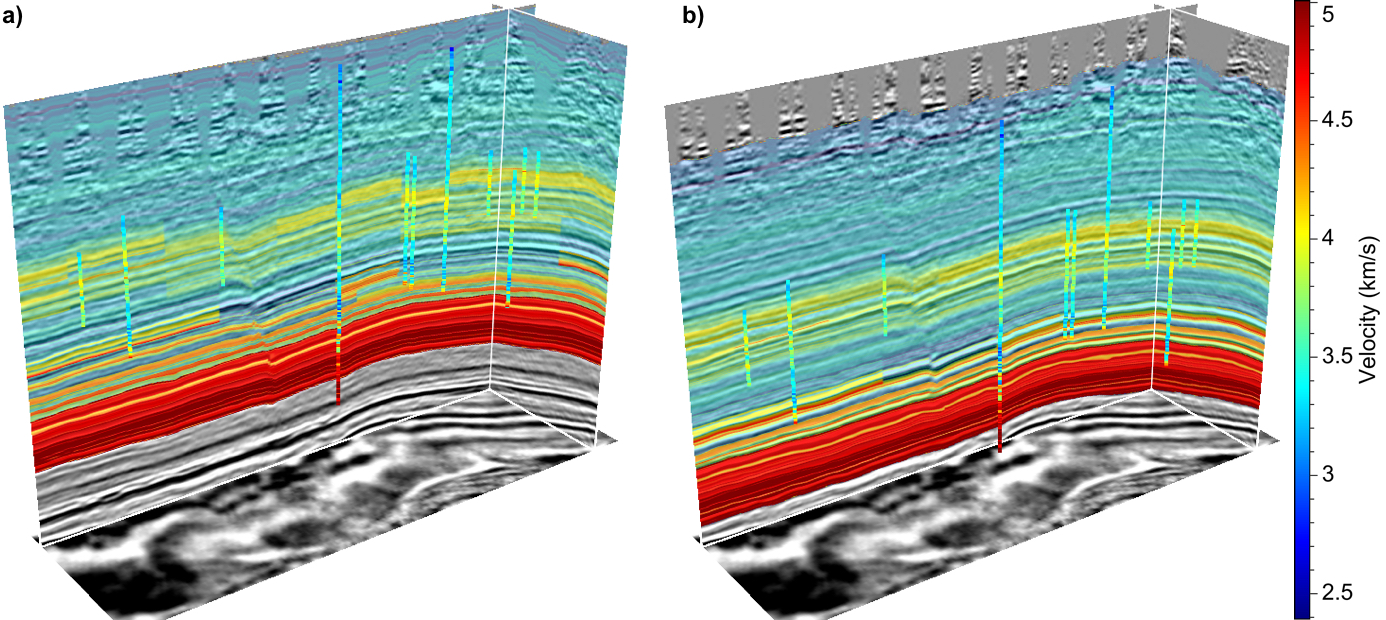
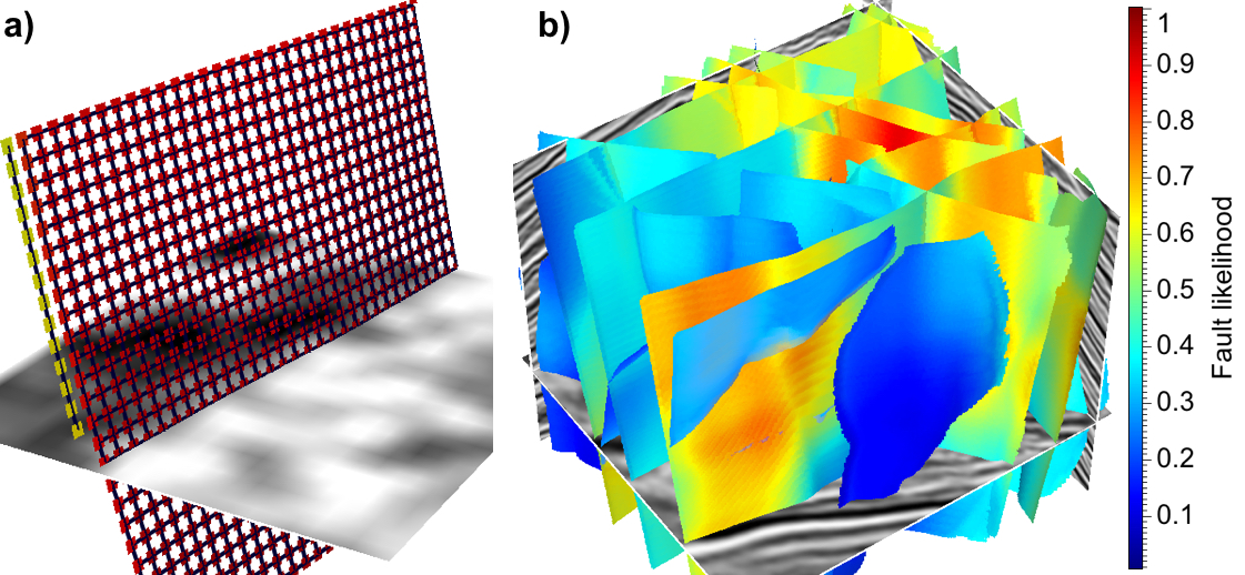
Geological Everything Model 3D: A Promptable Foundation Model for Unified and Zero-Shot Subsurface Understanding
构造、层序、地质体解释与井震联合建模一体化基础模型,Check [GEM's project page] for more detail.
- GEM (a) unifies subsurface imaging tasks such as structural interpretation, stratigraphic analysis, geobody segmentation, and property modeling within a single, prompt-driven generative framework. With self-supervised pre-training and adversarial fine-tuning, GEM emerges geologic understanding of subsurface images aligning with geologists' interpretations (b). GEM reformulates subsurface analysis as conditional generation guided by sparse, expert-provided prompts (e.g., masks, sketches, or well logs) propagated along a geological framework (b) inferred from an input subsurface image. This design enables zero-shot generalization across new surveys, geological settings, and data types without retraining or architectural changes.
- Dou, Y., X. Wu*, N. Bangs, H. Sethi, J. Li, and Z. Guo, 2025, Geological Everything Model 3D: A Promptable Foundation Model for Unified and Zero-Shot Subsurface Understanding, submitted. [GEM Project Page]
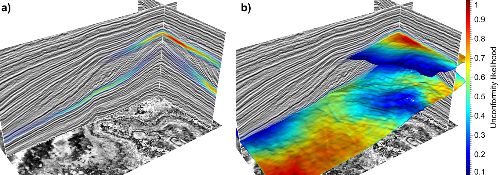
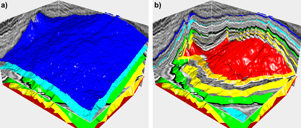
A geologically-informed and data-driven AI workflow for full seismic stratigraphic interpretation of sedimentary basin
地质先验约束的智能化全层序解释
- We implement a geologically-informed AI workflow (left Figure) for automatically interpreting a full stratigraphic volume of all horizons, stratal terminations, and unconformities of clinothems. First, we use the stratigraphic and geophysical forward modeling to simulate diverse stratigraphic clinofroms patterns and construct the labeled synthetic seismic datasets (first row of the Figure). Secondly, we utilize both labeled synthetic and unlabeled field datasets to train a transformer-based model with a hybrid loss built from synthetic labels and geologically-informed constraints. The geologically-informed losses (second row of the Figure) bring in numerous unlabeled field datasets for training and impose structural and stratigraphic consistency on the model’s predictions, improving its generalization capability across field surveys. With the trained model, we can compute the Wheeler diagrams and interpret all seismic stratigraphic horizons, depositional hiatuses, stratal terminations, as well as the spatial and temporal distributions of unconformities (third row of the Figure).
- Gao, H., X. Wu*, and X. Ding, 2025, A geologically-informed and data-driven AI workflow for full seismic stratigraphic interpretation of sedimentary basin, IEEE TGRS Vol. 63, 5917413. [PDF].
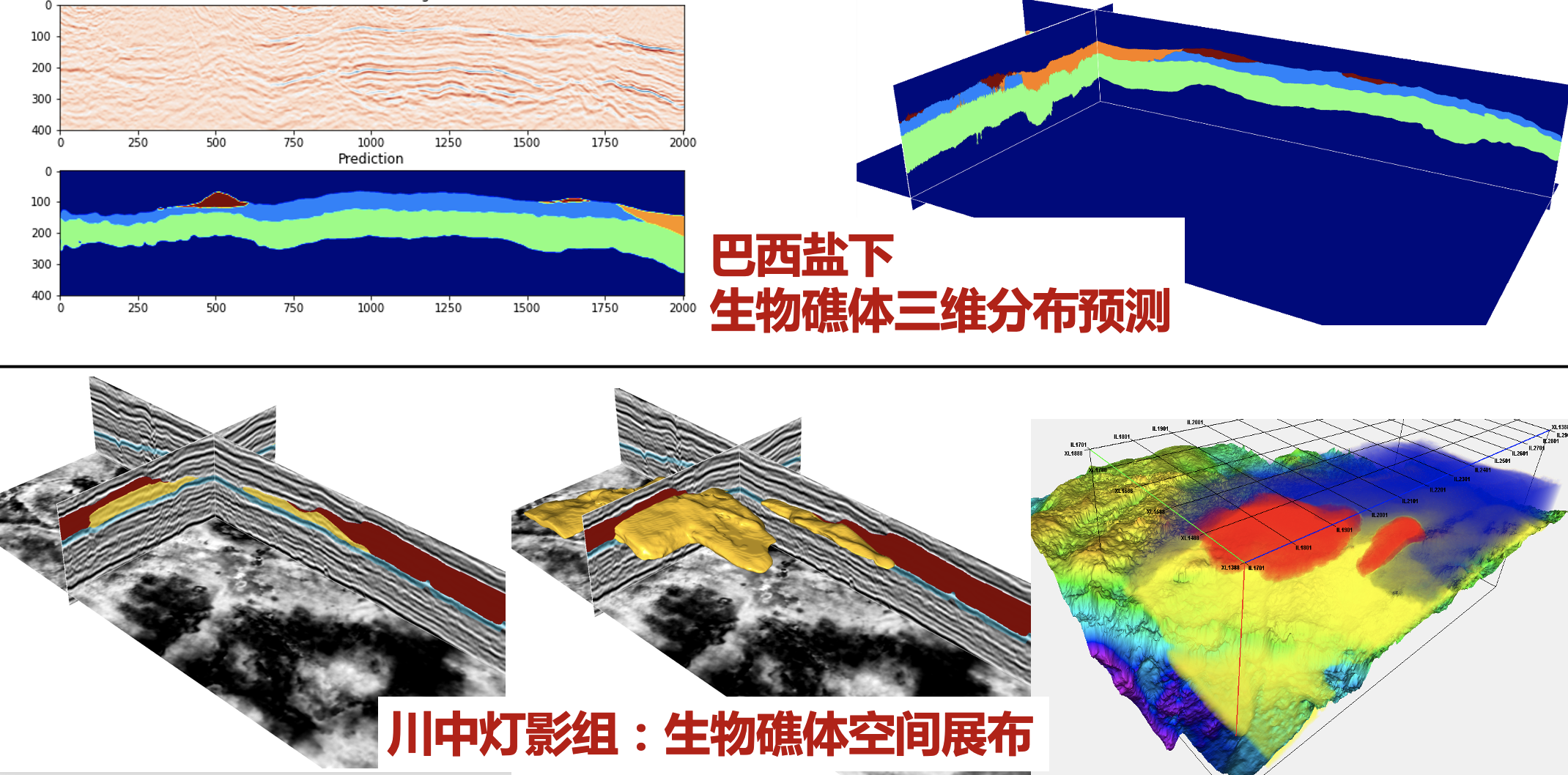
A foundation model enpowered by a multi-modal prompt engine for universal seismic geobody interpretation across surveys: 支持专家交互、跨工区泛化能力强的地质体解释通用大模型

- Our research introduces a foundation model equipped with a multi-modal prompt engine, enabling universal and interactive geobody interpretation across diverse seismic surveys. This approach addresses significant limitations in existing deep learning methods for seismic interpretation, including poor generalizability, geological and geophysical inconsistencies, and inadequate support for multimodal inputs. We believe our study establishes a new paradigm for applying pre-trained foundation models to geoscientific data analysis.
- Gao, H., X. Wu*, L. Liang, H. Sheng, X. Si, H. Gao, and Y. Li, 2025, A foundation model enpowered by a multi-modal prompt engine for universal seismic geobody interpretation across surveys, Information Fusion (IF=15.5), Vol. 125, 103437. [PDF].
Cross-Domain foundation model adaptation: pioneering computer vision models for geophysical data analysis
预训练视觉基础大模型在地球物理领域中的迁移适配
- Our research introduces an innovative workflow to efficiently adapt pre-trained foundation models (VFMs) for cross-domain and cross-task applications in geophysics. Our research examines three critical aspects: adaptation datasets, fine-tuning methods, and decoding modules, to explore the feasibility and effectiveness of this adaptation. Our findings introduce advanced machine learning techniques to geophysics, demonstrating the feasibility and advantages of cross-domain FM adaptation. This approach can drive further advancements in geophysical data analysis and provide valuable insights for applying FMs in other scientific fields.
- Guo, Z., X. Wu*, L. Liang, H. Sheng, N. Chen, and Z. Bi, 2024, Cross-Domain foundation model adaptation: pioneering computer vision models for geophysical data analysis, JGR, Machine Learning and Computation, JGR, Machine Learning and Computation, Vol. 2(1), e2025JH000601. [CODE], [PDF].
A graph neural network based workflow for real-time lightning location with continuous waveforms
基于图神经网络的闪电实时定位系统

- We propose a graph neural network (GNN) based method for accurate, real-time multi-station lightning location. Our approach processes continuous lightning waveform data from multiple sensors, achieving simultaneously denoising, event detection, and direct localization without arrival time picking. Synthetic and field examples demonstrate the our method outperforms traditional TOA (time of arrival) and TR (time reverse) algorithms in both efficiency and accuracy of lightning localization.
- Tian, C., X. Wu*, S. Qiu, Y. Li, and L. Shi, 2024, A Graph Neural Network Based Workflow for Real-time Lightning Location with Continuous Waveforms, JGR Atmosphere, 130, e2024JD042426. [PDF], [CODE].
cigChannels: a massive-scale 3D seismic data with labeled paleochannels for advancing deep learning in seismic interpretation: 大型古河道数据集
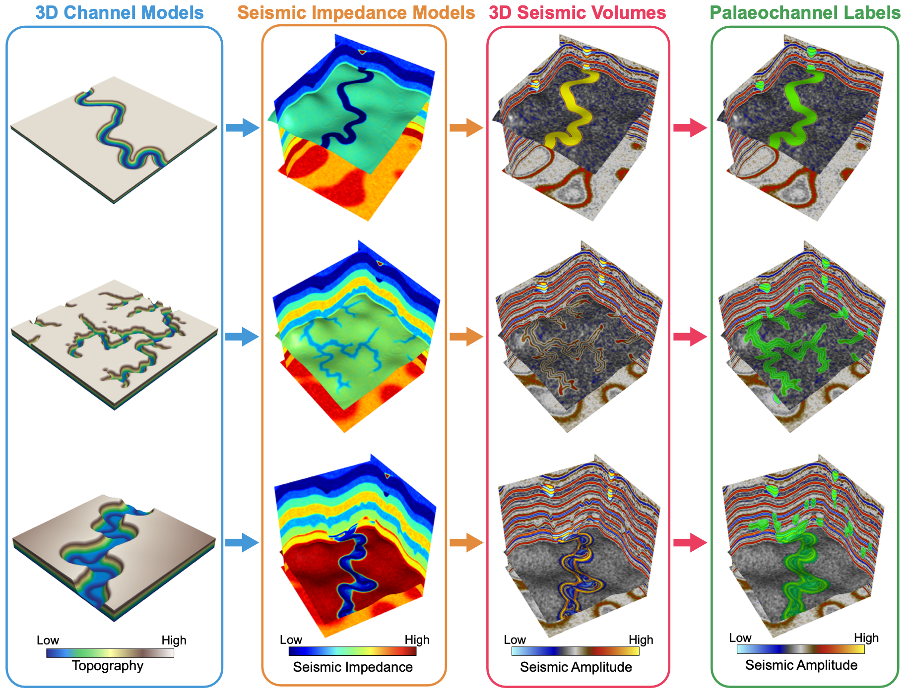
- To fill the gap of missing a comprehensive benchmark dataset of paleochannels, we present a workflow of geologic channel simulation and geophysical forward modeling to create a massive-scale synthetic seismic dataset containing 1,200 256×256×256 seismic volumes with labels of more than 10,000 diverse channels and their associated sedimentary facies. It is by far the largest dataset for channels, providing realistic and geologically reasonable seismic volumes with meandering, distributary, and submarine channels.
- Wang, G., X. Wu*, and W. Zhang, 2025, cigChannels: a massive-scale 3D seismic data with labeled paleochannels for advancing deep learning in seismic interpretation, Earth Syst. Sci. Data, 17, 3447–3471. [PDF], [CODE],
cigFacies: a massive-scale benchmark dataset of seismic facies and its application: 大型地震相数据集
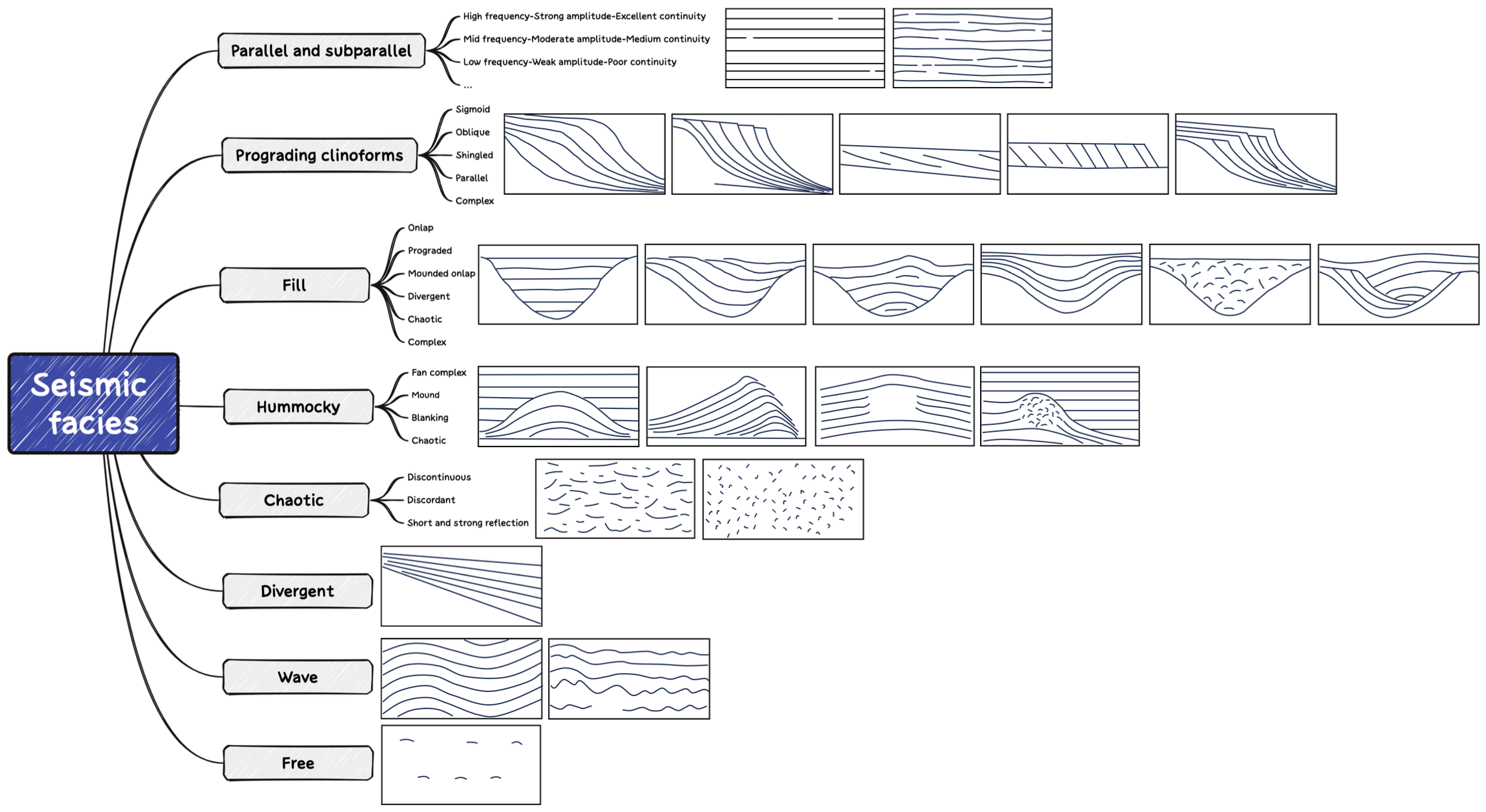
- The data-driven deep learning approaches are highly promising for automatic seismic facies classification with efficiency and accuracy, but lacking a comprehensive benchmark dataset of seismic facies severely limits its developments, applications, and evaluations in seismic facies classification. To tackle this limitation, we propose a workflow to construct a massive-scale benchmark dataset and evaluate its effectiveness in training a deep learning model. Specifically, We first develop a knowledge graph of seismic facies (left figure) based on the geological concepts and seismic reflection configurations. Guided by the graph, we then implement three strategies of field seismic data curation, knowledge-guided synthesization, and AI-based generation to construct the benchmark dataset of 8000 diverse samples. We have made this dataset, trained model and associated codes publicly available for further research and validation of intelligent seismic facies classification.
- Gao, H., X. Wu*, S. Xiao, M. Hou, H. Gao, G. Wang, and H. Sheng, 2025, cigFacies: a massive-scale benchmark dataset of seismic facies and its application, Earth Syst. Sci. Data, 17, 595–609. [PDF], [CODE], [Data].
CIGVis: an open-source Python tool for real-time interactive visualization of multidimensional geophysical data
基于Python的开源交互式三维可视化软件

- As Python’s role in processing and interpreting geophysical data expands, the need for a Python-based tool tailored for visualizing geophysical data has become increasingly critical. In response, CIGVis was developed - a fully open-source Python tool optimized for researchers and licensed under the MIT. It specializes in real-time, interactive visualiza- tion of multidimensional geophysical data, including 3D seismic, faults, horizons, geological bodies, and well logs. CIGVis enables users to interact with data through operations such as rotation, movement, zooming, and dragging slices. It also supports a multi-canvas functionality, allowing simultaneous visualization across multiple sub-canvases with a unified camera perspective. Its ease of use allows for effective visualization with just a few lines of code across all major operating systems, and extends to both desktop and Jupyter environments, facilitating code execution in various settings. The core functionalities of CIGVis are exemplified using straightforward datasets, such as the F3 dataset.
- Li, J., Y. Shi, and X. Wu*, 2025, CIGVis: an open-source Python tool for real-time interactive visualization of multidimensional geophysical data, Geophysics, Vol. 90(1), F1-F10. [PDF], [pypi], [CODE], [GIF-1], [GIF-2].
![[GIF-1]](/_upload/tpl/05/cd/1485/template1485/research/cigvis-2.gif)
![[GIF-2]](/_upload/tpl/05/cd/1485/template1485/research/cigvis-3.gif)
Seismic Foundation Model (SFM): a next generation deep learning model in geophysics: 地震基础模型
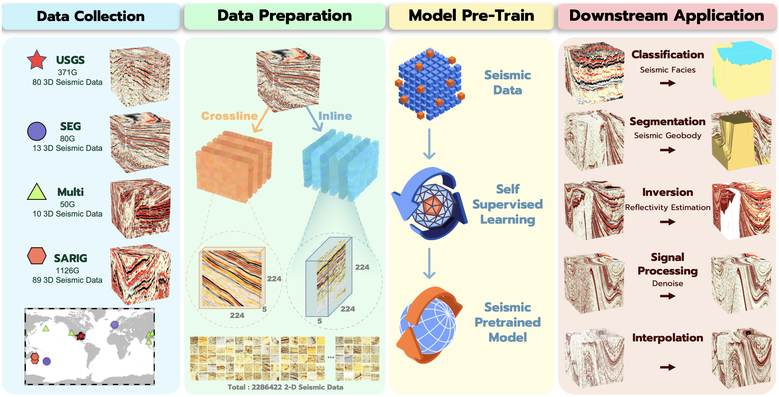
- We introduce a workflow to develop geophysical foundation models, including data preparation, model pre-training, and adaption to downstream tasks. From 192 globally collected 3-D seismic volumes, we create a carefully curated dataset of 2,286,422 2-D seismic images. Fully using these unlabeled images, we employ the self-supervised learning to pre-train a Transformer-based Seismic Foundation Model (SFM) for producing all-purpose seismic features that work across various tasks and surveys. Through experiments on seismic facies classification, geobody identification, interpolation, denoising, and inversion, our pre-trained model demonstrates versatility, generalization, scalability, and superior performance over baseline models.
- Sheng, H., X. Wu*, X. Si, J. Li, S. Zhang, and X. Duan, 2025, Seismic Foundation Model (SFM): a next generation deep learning model in geophysics, Geophysics, Vol. 90(2). [Code], [PDF]
Intelligent traffic monitoring with distributed acoustic sensing: 基于分布式光纤的智能交通监测
- We propose a two-step deep-learning workflow with high efficienncy and noise immunity for DAS-based traffic monitoring, including instance vechile trajactory segmentation and velocity estimation. We simulate synthetic datasets to train a Convolutional Neural Network (CNN) model in the first step of the workflow to detect linear vehiele trajectories from noisy DAS data in the time-space domain. In the step, we apply the Hough transform to convert the previously detected linear features into point-like energy clusters within the Hough domain, where we employ another CNN to concentrate the energies and pinpoint the most energetically significant points. By applying the inverse Hough transform to these points, we can reconstruct complete, distinct, and noise-free linear vehicle trajectories in the original time-space domain.
- Xie, D., X. Wu*, Z. Guo, H. Hong, B. Wang, and Y. Rong, 2025, Intelligent traffic monitoring with distributed acoustic sensing, SRL, in press.
SeisCLIP: A seismology foundation model pre-trained by multi-modal data for multi-purpose seismic feature extraction
SeisCLIP: 基于多模态数据的地震学预训练基础模型

- We introduce SeisCLIP: a foundation model for seismology, leveraging contrastive learning on multi-modal data of seismic waveform spectra and the corresponding local and global event information. SeisCLIP consists of a transformer-based spectrum encoder and an MLP-based information encoder that are jointly pre-trained on massive data. Remarkably, the pre-trained spectrum encoder offers versatile features, enabling its application across diverse tasks and regions. Thus, it requires only modest datasets for fine-tuning to specific downstream tasks. Our evaluations demonstrate SeisCLIP's superior performance over baseline methods in tasks like event classification, localization, and focal mechanism analysis, even when using distinct datasets from various regions. In essence, SeisCLIP emerges as a promising foundational model for seismology, potentially revolutionizing foundation-model-based research in the domain.
- Si, X., X. Wu*, H. Sheng, J. Zhu, and Z. Li, 2023, SeisCLIP: A seismology foundation model pre-trained by multi-modal data for multi-purpose seismic feature extraction, IEEE TGRS, Vol. 62, pp. 1-13, Art no. 5903713. [Code], [PDF]
CNN-based interpretation of fault damage zones in 3D seismic data: 地震数据中破碎带智能刻画,填补实验室/露头数据空白

- We present a CNN-based method to automate the interpretation of fault damage zones (FDZ) in 3D seismic volumes, including the FDZ detection, 3D modeling, and quantitative estimation of the FDZ displacement and thickness. Through our seismic FDZ interpretation, we fill the observation gap for FDZs with fault displacements between 200 and 500 meters, a gap that typically exists in traditional laboratory and field outcrop data. Leveraging the estimated geometrical attributes, we can automatically perform scaling analysis of fault damage zones and gain further understanding of fault growth.
- Gao, H., X. Wu*, J. Li*, and Z. Liao, 2023, Deep learning-based interpretation of fault damage zones in 3D seismic data, JGR Solid Earth, submitted.
Multi-task multi-station earthquake monitoring:
An all-in-one seismic Phase picking, Location, and Association Network
Seismic PLAN(Phase picking, Location, & Association Network): 一种多台站多任务智能地震监测系统

- We propose a deep learning-based earthquake monitoring model that directly operates on multi-station seismic data and achieves simultaneous phase picking, association, and location. To the best of our knowledge, this is the first multi-station and multi-task earthquake monitoring model developed in the field. It is informed with both inter-station and inter-task physical relationships to promote accuracy, interpretability and consistency among cross-station and cross-task predictions. Our work demonstrates that inter-station and inter-task constraints could be a keystone for next-generation earthquake monitoring systems.
- Si, X., X. Wu*, Z. Li*, S. Wang, and J. Zhu, 2023, Multi-task multi-station earthquake monitoring: An all-in-one seismic Phase picking, Location, and Association Network (PLAN), Communications Earth & Environment, Vol. 5(22). [PDF], [CODE].
FlexLogNet: a well-log completion method of adaptively using what you have to predict what you are missing
FlexLogNet: 有什么用什么,缺什么补什么

- We propose a hybrid deep learning method with two heads of graph neural network (GNN) and fully connected network (FCN) to achieve mutual prediction among multiple types of well logs. It can adaptively use all known well logs in actual data to predict any missing well log, achieving a very flexible and practical well log completion function of using what you have and completing what you are missing.
- Dai, C., X. Si, and X. Wu*, 2023, FlexLogNet: a flexible deep learning-based well-log completion method of adaptively using what you have to predict what you are missing, Computers & Geosciences, 191, 105666. [PDF].
Sensing prior constraints in deep neural networks for solving geophysical problems
在地球物理问题的深度学习解决方案中引入先验约束
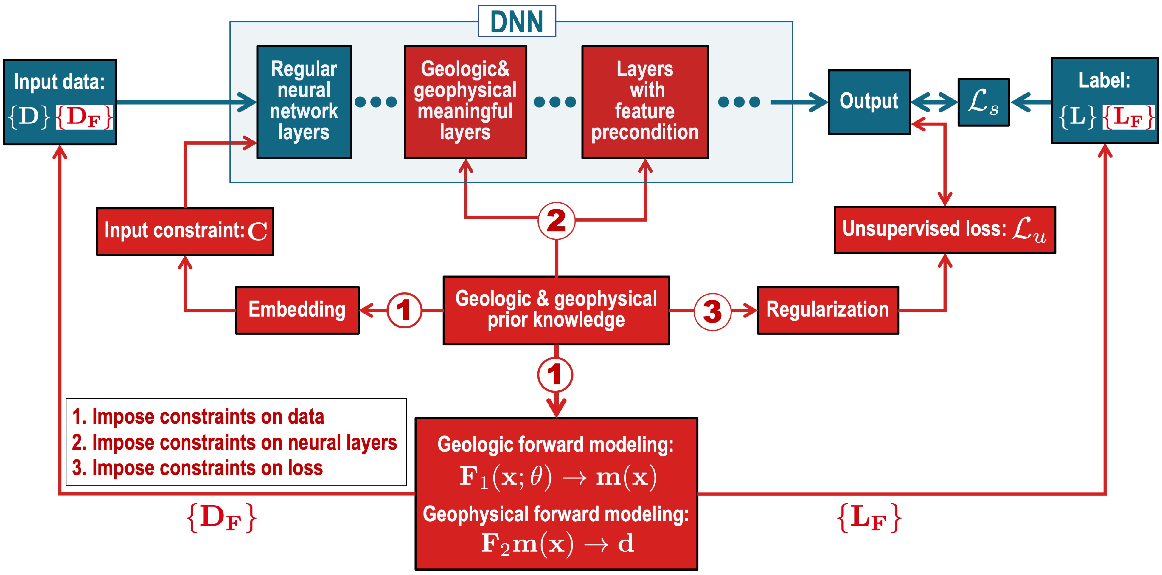
- We present three general strategies to effectively incorporate geological and/or geophysical constraints into DNNs. They help address the main challenges of poor generalizability, weak interpretability and physical inconsistency that are commonly faced when applying DNNs to solve geophysical problems. In discussing each of the three strategies, we provide examples of applications to demonstrate their effectiveness.
- Wu, X., J. Ma*, S. Xu, Z. Bi, J. Yang, H. Gao, D. Xie, Z. Guo, and J. Zhang*, 2023, Sensing prior constraints in deep neural networks for solving geophysical problems, PNAS, Vol. 120(23), e2219573120. [PDF].
Deep learning-based sferics recognition for AMT data processing in the dead band
天电信号智能识别及其在“死频带”音频大地电磁数据处理中的应用
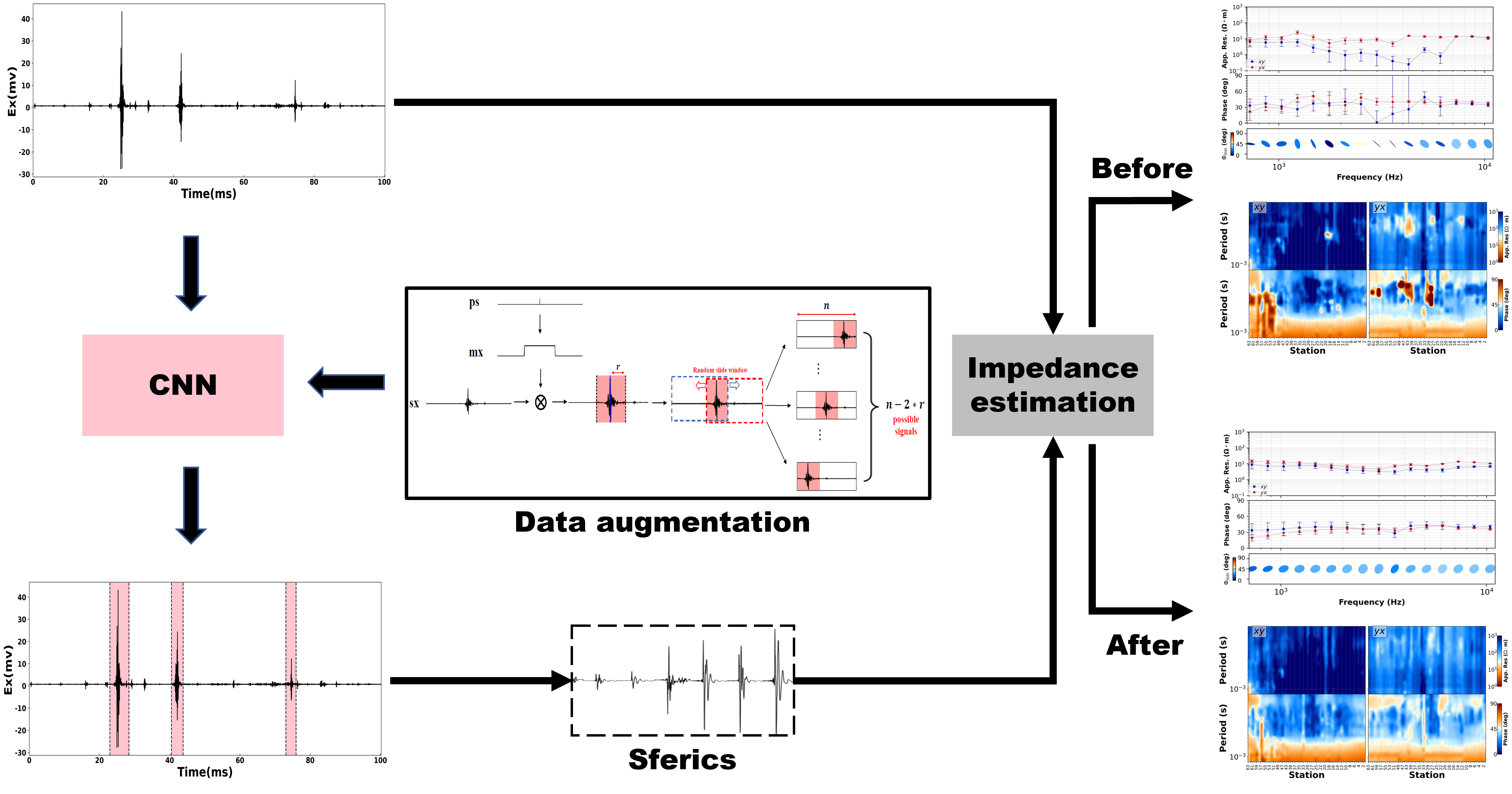
- In the audio magnetotellurics (AMT) sounding data processing, the absence of sferic signals in some time ranges typically results in a lack of energy in the AMT dead band, which may cause unreliable resistivity estimate. We propose a deep convolutional neural network (CNN) to automatically recognize sferic signals from redundantly recorded data in a long time range and use them to compensate for the resistivity estimation in the dead band.
- Jiang, E., R. Chen*, X. Wu*, J. Liu, D. Zhu, and W. Liu, 2023, Deep learning based sferics recognition for AMT data processing in the dead band, Geophysics, Vol. 88(5), B233–B250. [PDF].
Horizon controlled few-shot learning for seismic facies identification
基于层控约束下小样本学习的地震相智能识别
- We propose a seismic facies classification method based on few-shot learning with the constraints of prior models and present applications in real cases in China. This method can achieve a geologically reasonable facies identification with a very small amount of labeled seismic slices.
- Sun, X., Z. Bi, X. Wu*, Y. Ye, C. Yang, and H. Meng, 2022, Seismic facies identification based on few-shot learning with the constraints of seismic horizons, Geophysics, submitted.
Transformer-based multi-task learning for RGT, horizons, and faults with prior constraints
先验约束下的RGT、层位和断层多任务Transformer架构实现
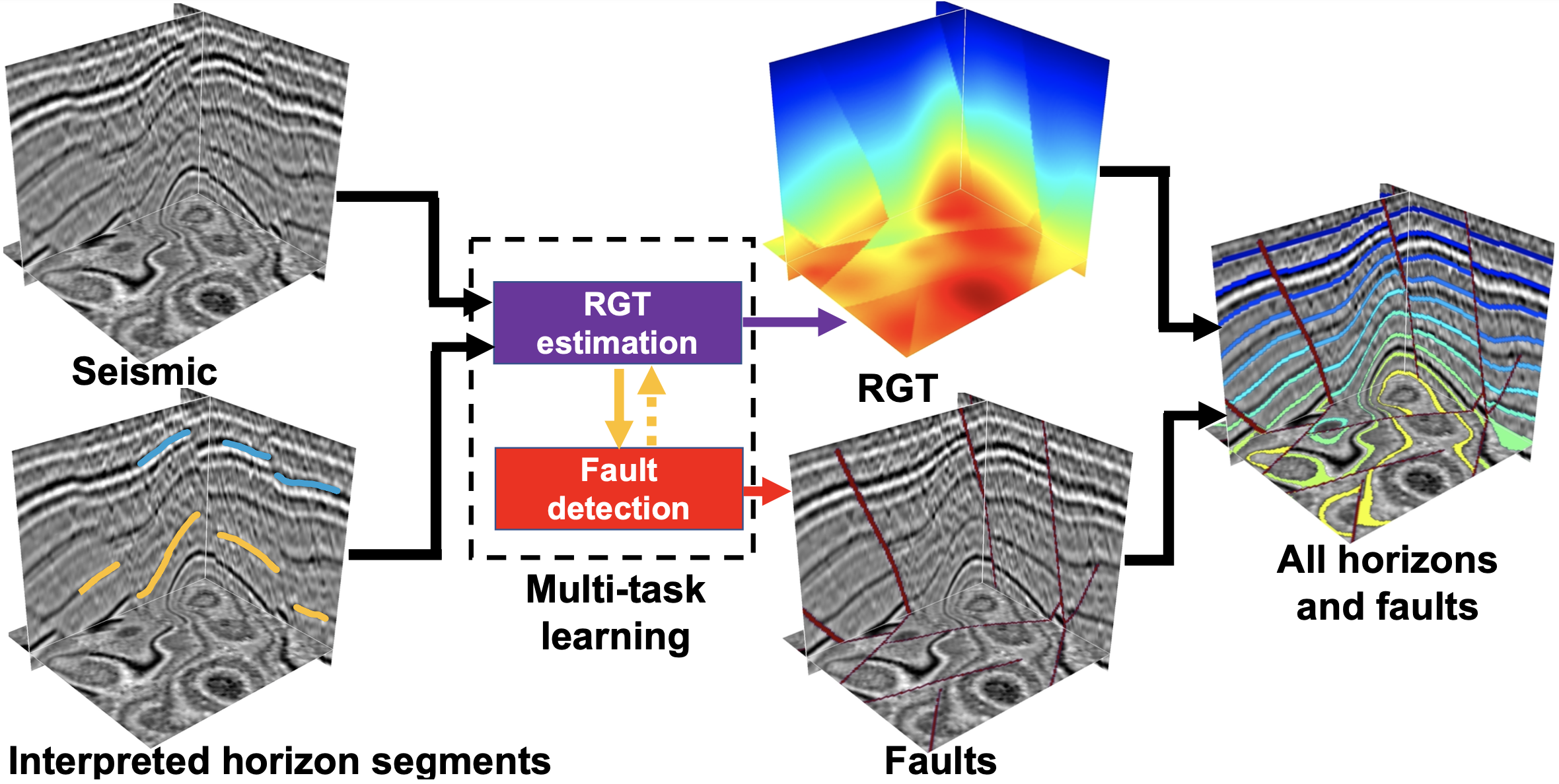
- We propose a transformer-based multi-task learning (MTL) network to extract all horizons and detect faults simultaneously by estimating a relative geologic time (RGT) map as well as computing a fault map. We enable convenient human interactions by integrating manually interpreted horizons (or horizon segments) into the network, which imposes expert knowledge on the network to predict reasonable results from seismic images with complex fault systems, unconformities, and poor data quality.
- Yang, J., X. Wu*, Z. Bi, and Z. Geng, 2023, A multi-task learning method for relative geologic time, horizons, and faults with prior information and transformer, IEEE TGRS, vol. 61, pp. 1-20, Art no. 5907720, doi: 10.1109/TGRS.2023.3264593. [PDF].
ClinoformNet: stratigraphic forward modeling and deep learning for seismic clinoform delineation
层序地层正演模拟与地震坡体智能识别
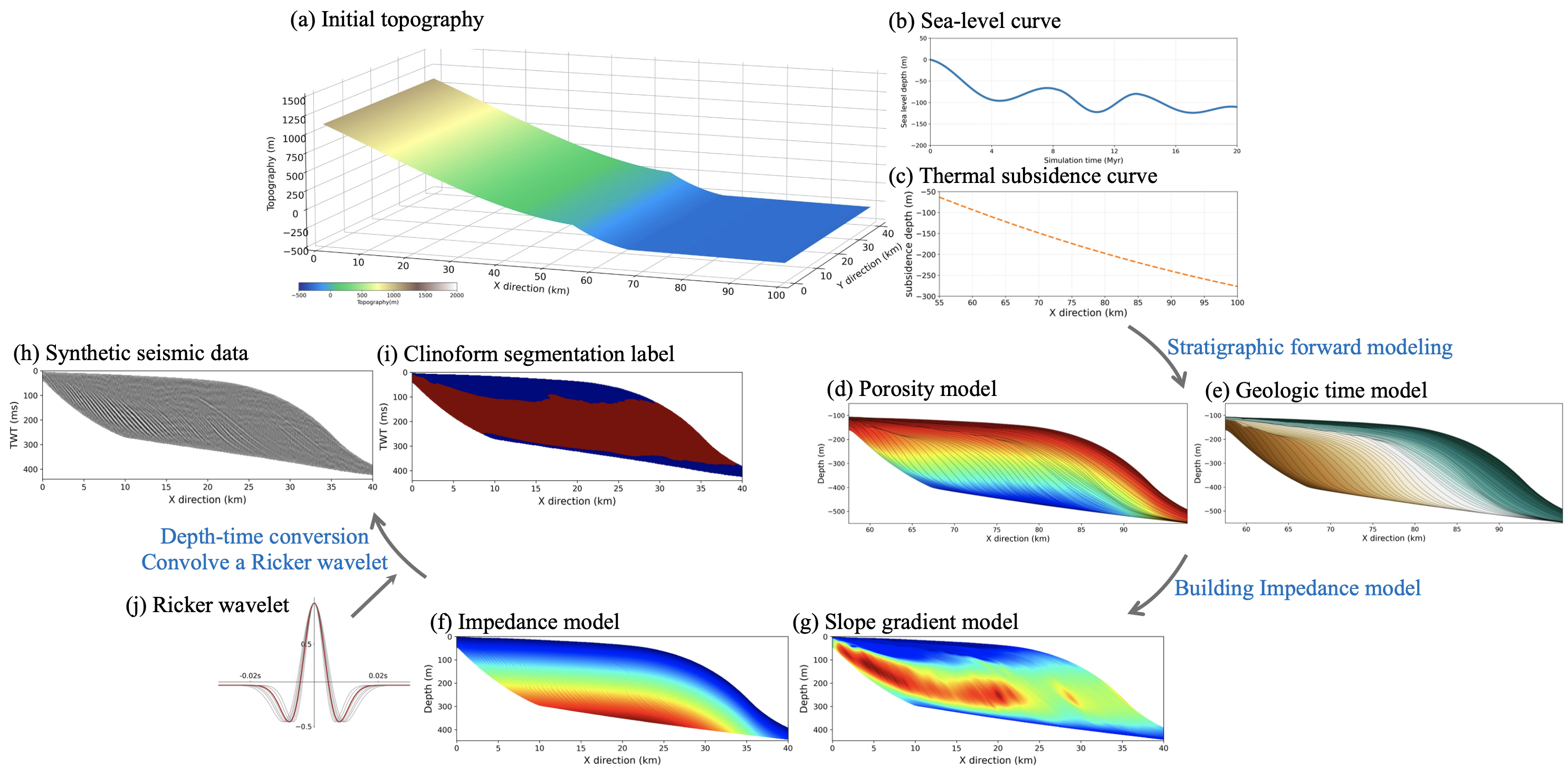
- We perform 3D stratigraphic forward modeling to simulate strata layers and their physical properties (e.g., porosity, velocity, impedance). We further perform geophysical forward modeling to generate synthetic seismic data and the corresponding stratigraphic labels which are used to train deep neural networks for the reverse process of interpreting stratigraphic stories behind the seismic data.
- Gao, H., X. Wu*, and J. Zhang, 2023, ClinoformNet-1.0: stratigraphic forward modeling and deep learning for seismic clinoform delineation, GMD, Vol. 16(9), 2495–2513. [PDF].
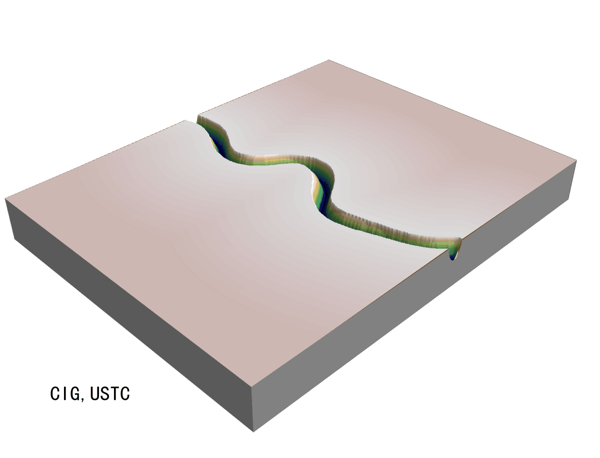
Stratigraphic forward modeling, by Hui Gao
地层正演模拟, 高晖
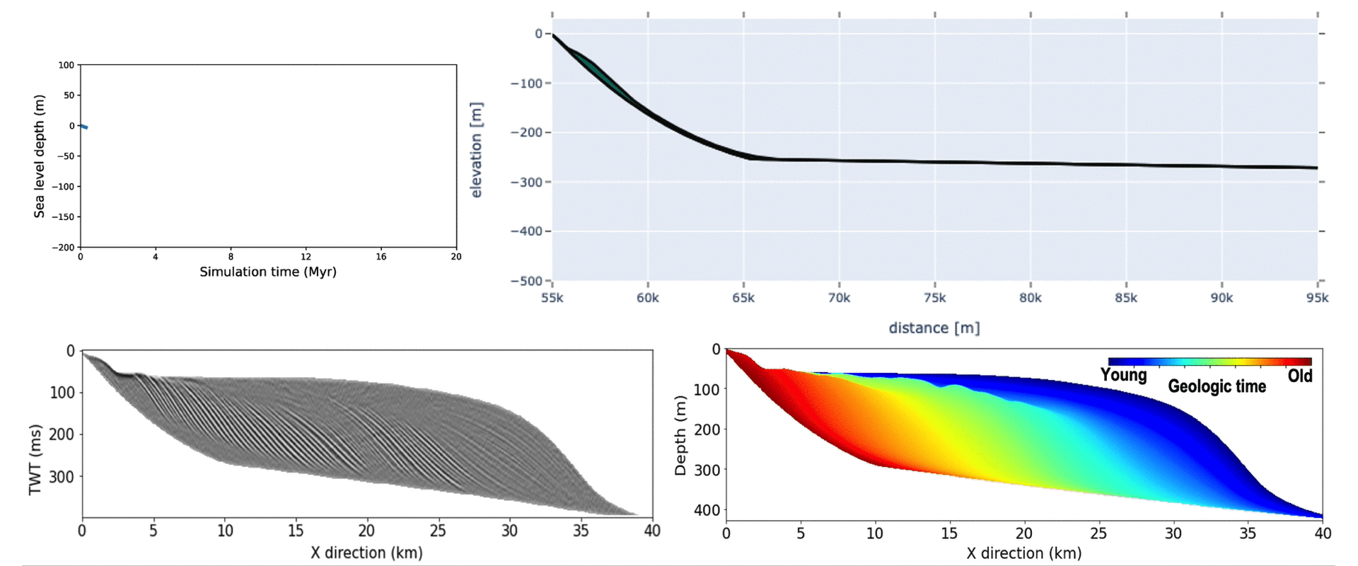
- We have been working on forward numerical simulation of various geologic processes, which would be helpful for us to understand the geologic processes themselves and to imagine the geologic stories behind geophysical datasets. This example shows a numerical implementation of 2D stratigraphic forward modeling that is controlled by an initial topography, sea level curve, and thermal subsidence curve.
Deep learning for characterizing CO2 migration in time-lapse seismic images
基于时延地震的CO2运移智能检测
- We propose a deep-learning-based method to efficient characterize CO2 plumes in time-lapse seismic data. We train the deep neural network by using synthetic datasets with simulated diffusive CO2 plumes that are various in geometric features (e.g., shapes, sizes, and locations) and physical properties (e.g., densities and velocities). We applied the trained network work to the Sleipner time-lapse seismic data and obtain reasonable CO2 plume predictions that are consistent with human interpretations. To more accurately characterize the CO2 plume migration, we use dynamic image warping to compute relative shifts that register the time-lapse seismic volumes before and after CO2 injection and then apply the same shifts to the predicted CO2 plumes. By doing this, we are able to reduce the inconsistencies that may be introduced by acquisition, processing, push-down effect (velocity decrease by injected CO2), and pull-up effect (wavelet distortion), which is helpful to more accurately characterize the CO2 plume migration.
- Sheng, H., X. Wu*, X. Sun, and L. Wu, 2023, Deep learning for characterizing CO2 migration in time-lapse seismic images, Fuel, Vol. 336, 126806. https://doi.org/10.1016/j.fuel.2022.126806. [PDF].
Stratal surfaces honoring seismic structures and interpreted geologic time surfaces
地震构造和地质等时面引导的混合地层切片方法

- In basin and regional interpretations, the assumption that seismic horizons represent a stratigraphic surface with constant geologic time may fail, however, when applied to local reservoir scales due to seismic resolution, complex depositional facies transition, and an indented stack of depositional units. To address this limitation, we develop a novel horizon extraction method honoring both seismic structures and time-stratigraphic frameworks, in which seismic reflection structures provide local details and interpreted geologic-time surfaces provide critical constraints in interpreting these reflection events not following geologic surfaces. First, we develop concepts and workflow using a realistic outcrop model. We propose using the improved geology-guided structure tensor by fitting a gradient vector of seismic image and the geological time surfaces. We also consider existing geologic conditions, such as unconformity, and fuse them into calculating accurate slopes and generating reliable relative geologic time (RGT) images at a fine scale, followed by making slices.
- Wang, F., X. Wu*, H. Zeng, X. Janson, and C. Kerans, 2022, Stratal surfaces honoring seismic structures and interpreted geologic time surfaces. Geophysics, Vol. 89(2), N45–N57. [PDF].
3D Implicit structural modeling with convolutional neural network
智能隐式构造建模
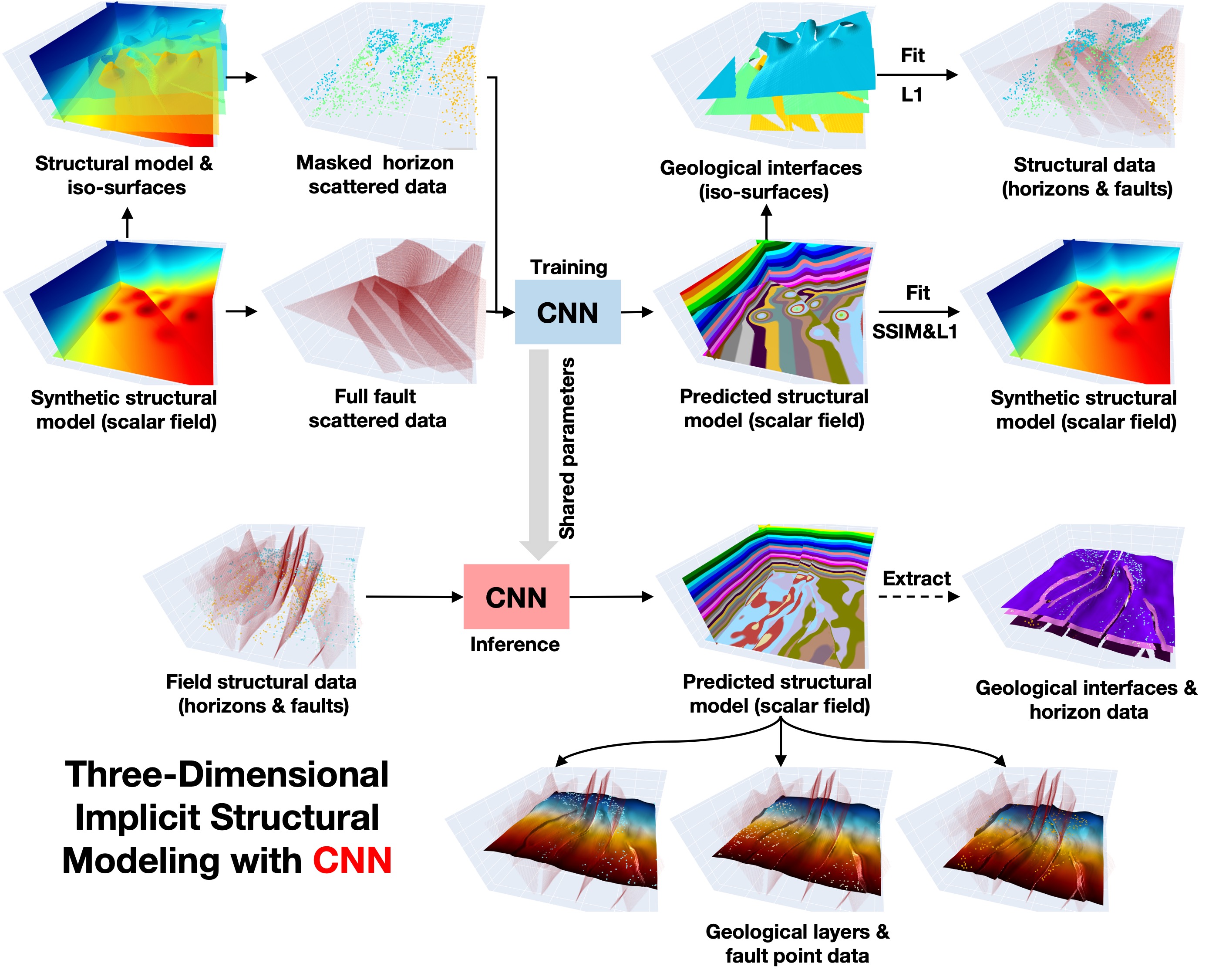
- Given sparse structural data points, implicit structural modeling computes a scalar field by solving partial differential equations (PDEs) to implicitly represent structural information of the subsurface. However, the PDEs might be insufficient to model highly complex structures in practice and may fail to reasonably fit a global structure trend when the known data are too sparse. In addition, solving the PDEs with iterative optimization solvers could be computationally expensive in 3-D. We propose an efficient deep learning method using a convolution neural network to predict a scalar field from sparse structural data associated with multiple stratigraphic layers and faults. After training with synthetic datasets, our network is able to efficiently predict geologically reasonable and structurally consistent implicit models in field examples, opening new opportunities for improving the efficiency and accuracy of geological modeling.
- Bi, Z., X. Wu*, Z. Li, D. Chang, and X. Yong, 2022, DeepISMNET: 3D Implicit structural modeling with convolutional neural network. Geoscientific Model Development (GMD), Vol. 15(17), 6841–6861. [PDF].
Filling borehole image gaps with partial convolution neural network
基于部分卷积神经网络的成像测井空白带补全

- Due to the special design of borehole imaging tools, vertical strips of gaps often occur in borehole images. We propose a reasonable way to fill borehole image gaps through a convolutional neural network with partial convolution layers. The partial convolution helps eliminate the affects of the null data during the training by excluding the null-data areas from convolutional computations in the forward and backward propagation of updating the network parameters. To solve the problem of missing training labels, we introduce a self-supervised learning strategy to train the network to fill the image gaps from the image itself. We compare our method with a conventional method (implemented in the CIFLOG software) and two deep-learning based methods (DGP and DIP) by applying them to multiple real borehole images with various pattern features. Quantitative metrics show that our method is superior to the others.
- Jiang, L., X. Si, and X. Wu*, 2024, Filling borehole image gaps with partial convolution neural network. Geophysics, Vol. 89(2), D289–D98. [PDF].
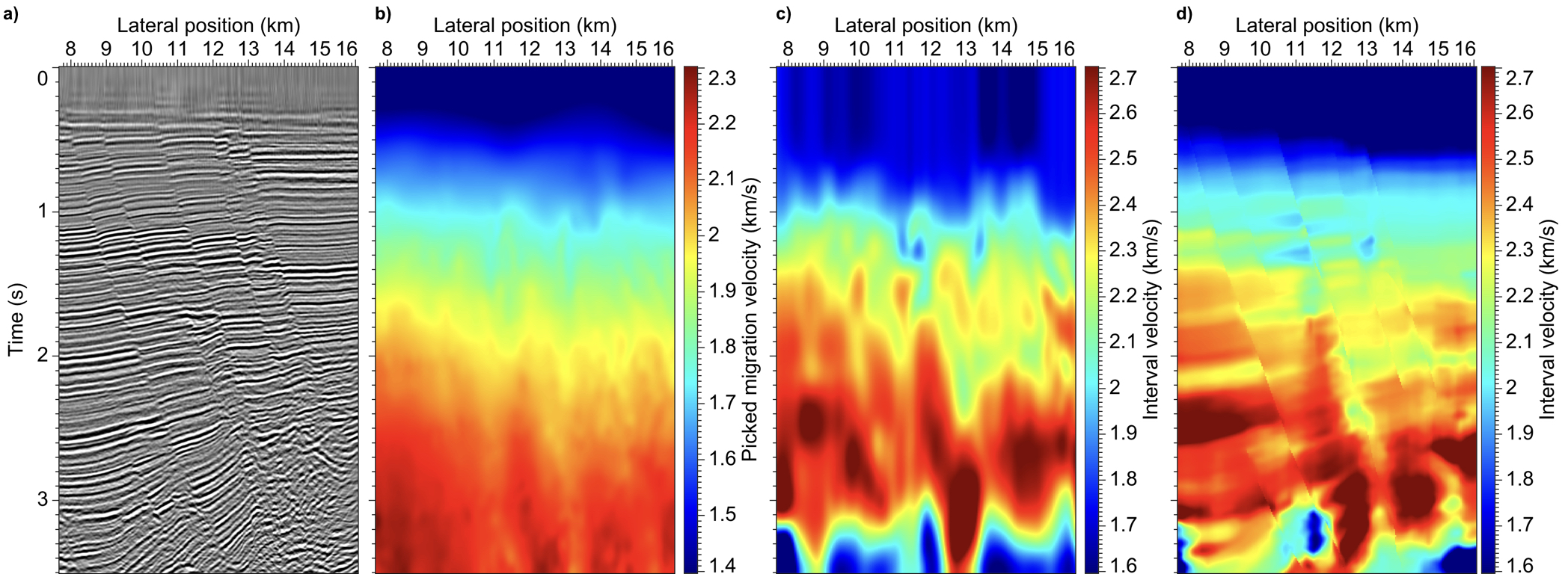
Automatic velocity analysis with physics-constrained optimal surface picking
基于物理约束最优面拾取的速度分析
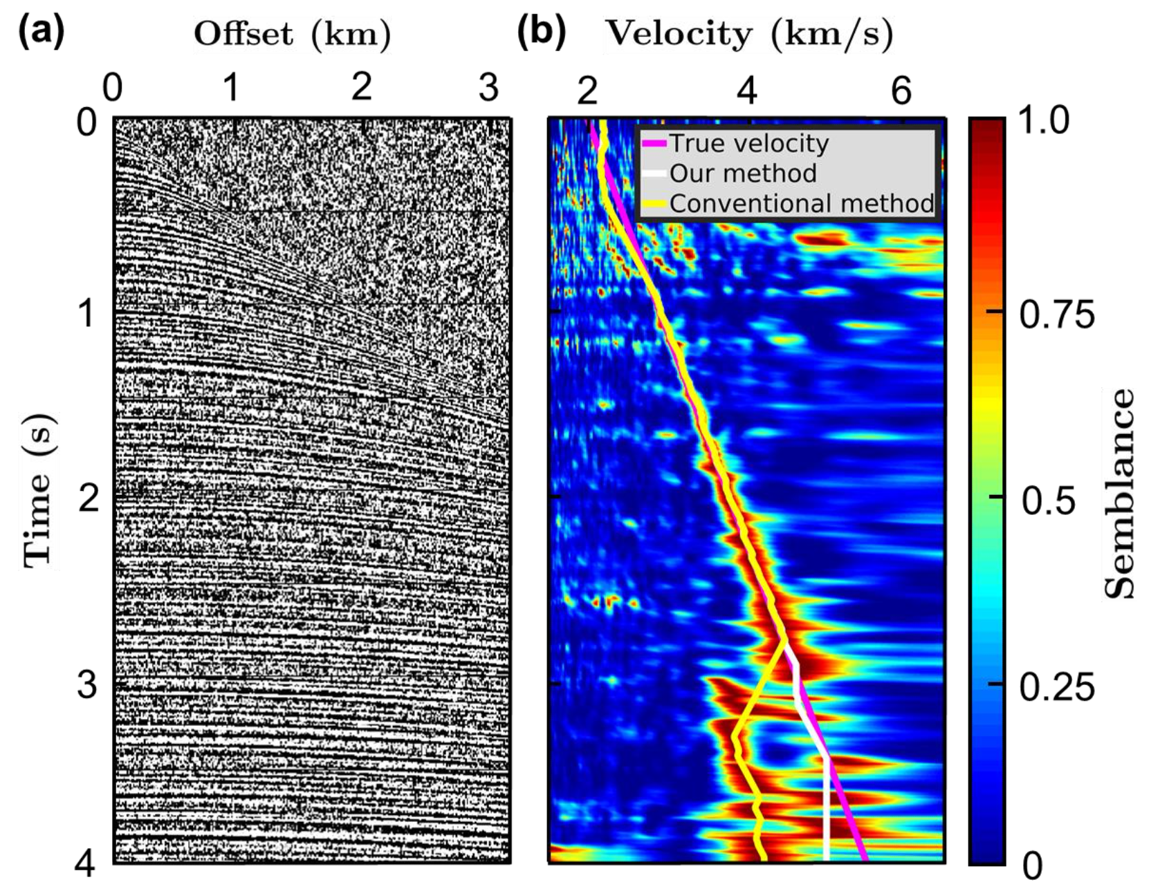
- We propose a constrained optimal surface picking method to automatically pick a 2D velocity field from a 3D semblance volume with high efficiency and robustness. This method is improved from the 2D dynamic programming algorithm by incorporating both vertically physical constraints in the time direction and laterally smoothness constraints in the common midpoint (CMP) direction. The time-direction physical constraint ensures the picked velocity is positive when converted to interval velocity, which is helpful to avoid picking physically unreasonable velocities along the strong and spatially consistent semblance energy due to consistent noise or multiples (as shown in the left Fig. b). The CMP-direction smoothness constraint ensures the picked 2D velocity field is laterally continuous.
- Xue, Z. and X. Wu*, 2023, Automatic velocity analysis with physics-constrained optimal surface picking. Geophysics, Vol. 88(3), U71–U80. [PDF].
Unsupervised contrastive learning for seismic facies characterization
无监督对比学习地震相分类
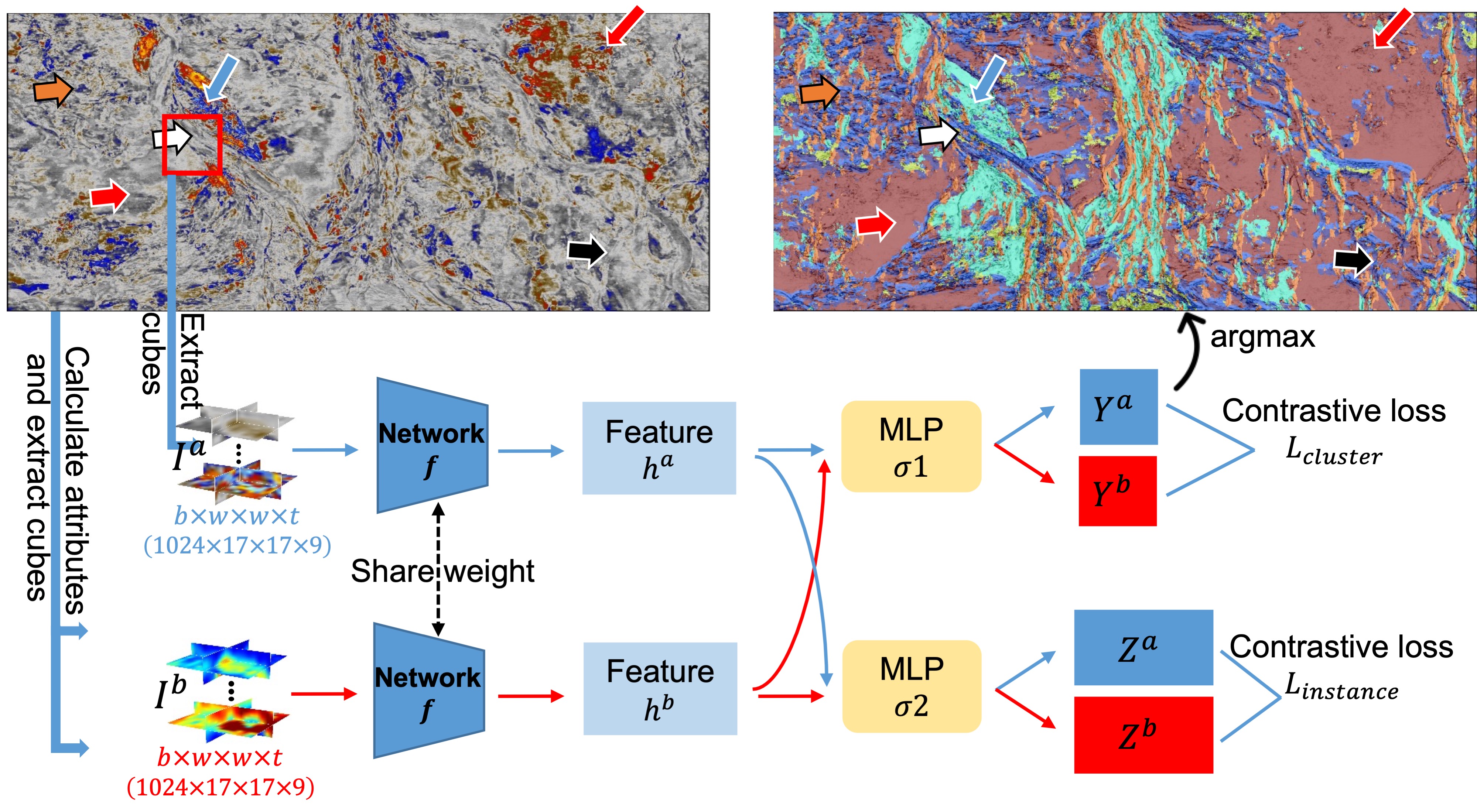
- We propose to leverage a one-stage and end-to-end contrastive learning framework without any manual labels to automatically analyze seismic facies. To improve lateral consistency, we input 3D seismic cubes, instead of traces, into the neural network. Besides, we treat seismic attributes as geologic constraints and feed them into the network along with the seismic cubes. Our contrastive learning method is used to maximize the similarities of the different cubes from the same position, and minimize the similarities of the cubes from different positions. In this way, we are able to enforce the samples with similar features to get close while push the samples with different features to be separated in the space where we make the seismic facies clustering. We apply this method to a field turbidite channel system and obtain a continuous and reasonable facies map.
- Li, J., X. Wu*, Y. Ye, C. Yang, Z. Hu, X. Sun, and T. Zhao, 2023, Unsupervised contrastive learning for seismic facies characterization, Geophysics, Vol. 88(1), WA81–WA89. [PDF].
基于声呐图像的海底线缆智能实时探测
Deep learning for realtime detection of submarine cables in sonar images
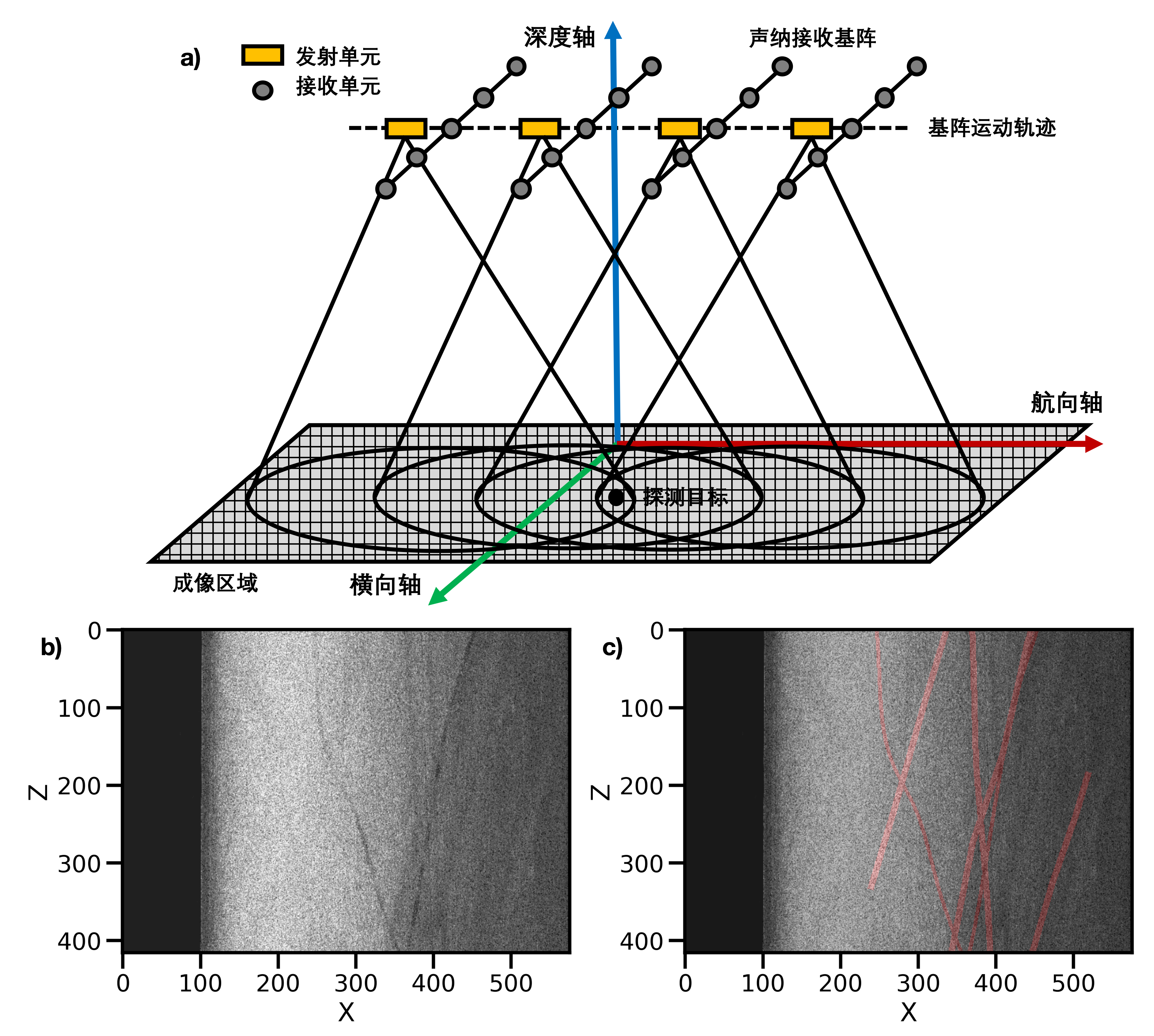
- 近年来,我国海底通讯和监测线缆布设日益增长;同时,一些国家在我国周边海域布设了大量水下线缆监测系统,对我国领海安全造成严重威胁。因此,对海底线缆布设的探明是保障我国海洋开发和国防安全的当务之急。声呐技术是探测海底线缆的有效手段,但是在对海底进行大规模扫描过程中产生海量的声呐图像,面临图像处理耗时长和解译精度低等难题。本文提出一种基于卷积神经网络的缆线目标自动检测技术,实现对大量声呐图像数据端到端的快速、精确解译。该网络以编码器和解码器组成的U型架构,利用残差学习模块和跳连机制,能系统地聚合多尺度特征模式,并根据不同的特征动态生成索引函数,以指导不同尺度层级间的重采样操作和信息融合,从而实现对输入图像中所有不同尺度缆线目标体的精确且快速地识别。为获取足够多的样本数据以训练网络,我们提出一套方法流程来自动生成大量且逼真的声呐图像以及对应缆线标注。我们提出多种量化评价指标系统来对比评价了该网络和目前主流图像分割网络的性能表现。相对于其他主流图像分割网络,我们方法在多个合成数据测试和实际数据应用中均取得更好的效果。
- 毕钲发, 刘杨, 伍新明*, 吴丽丽, 2022, 基于声呐图像的海底线缆智能实时探测 (Deep learning for realtime detection of submarine cables in sonar images), 地球物理学报, 已接收。
Deep learning for efficient microseismic location using source migration-based imaging
基于深度学习的微地震定位
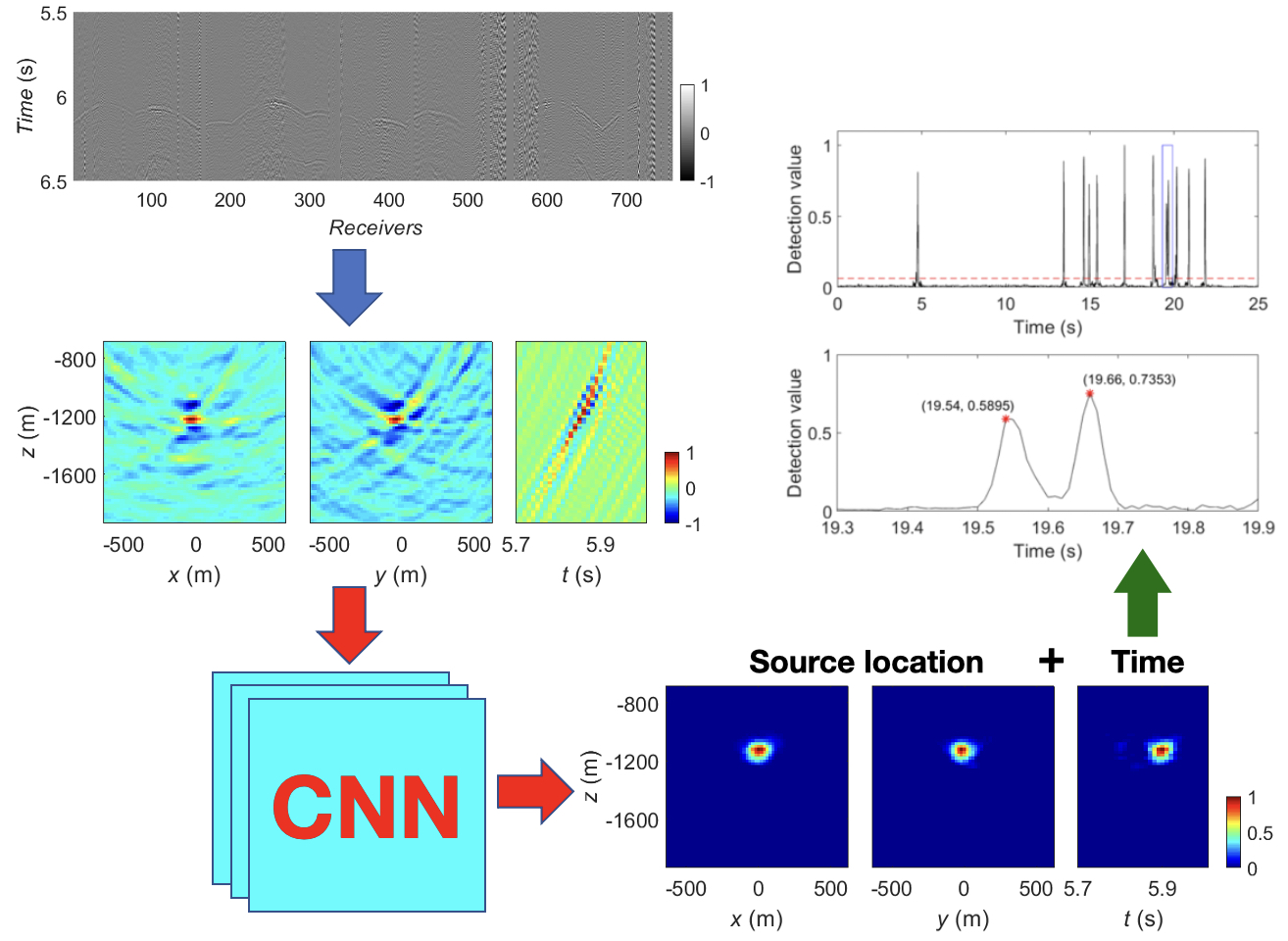
- Migration-based location methods (e.g., time reversal imaging based on wave equation, Kirchhoff summation and diffraction stacking) are widely used to effectively locate events of low signal to noise ratios by stacking waveforms from many receivers. However, these methods may not produce accurate results if there are polarity reversals in the surface records for a double-couple or even a general moment tensor event. We propose a deep convolutional neural network to predict a better-focused image from a regular migration image that contains a quasi symmetric pattern in both space and time. Zhang, Q., W. Zhang*, X. Wu*, J. Zhang, W. Kuang, and X. Si, 2021, Deep Learning for efficient microseismic location using source migration-based imaging. JGR, Solid Earth, 127(3), e2021JB022649. [PDF].
Toward accurate seismic flattening
走向精确地震体拉平
- Seismic flattening maps a seismic volume from the original space in depth to the Wheeler domain in geologic time where all the seismic reflections are horizontally aligned. It provides an efficient way to interpret a whole volume of horizons all at once by simply extracting horizontal slices in the flattened space. Conventional flattening methods, based on seismic local slopes, can locally flatten the seismic reflections, however, often fail to flatten the reflections in a global sense and cannot accurately align the reflections across faults. We propose an iterative method to improve the flattening by using both slopes and correlations of seismic traces. Wu X.*, Y. Li, and P. Sawasdee, 2022, Toward accurate seismic flattening: methods and applications. Geophysics, Geophysics, Vol. 87(5), IM177–IM188. [PDF].
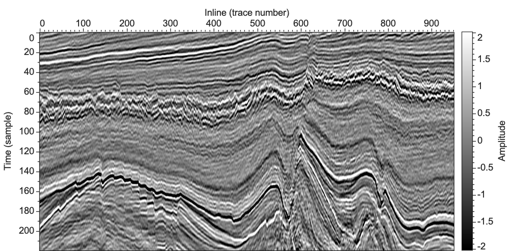
Seismic structural interpretation and modeling
地震构造解释与建模
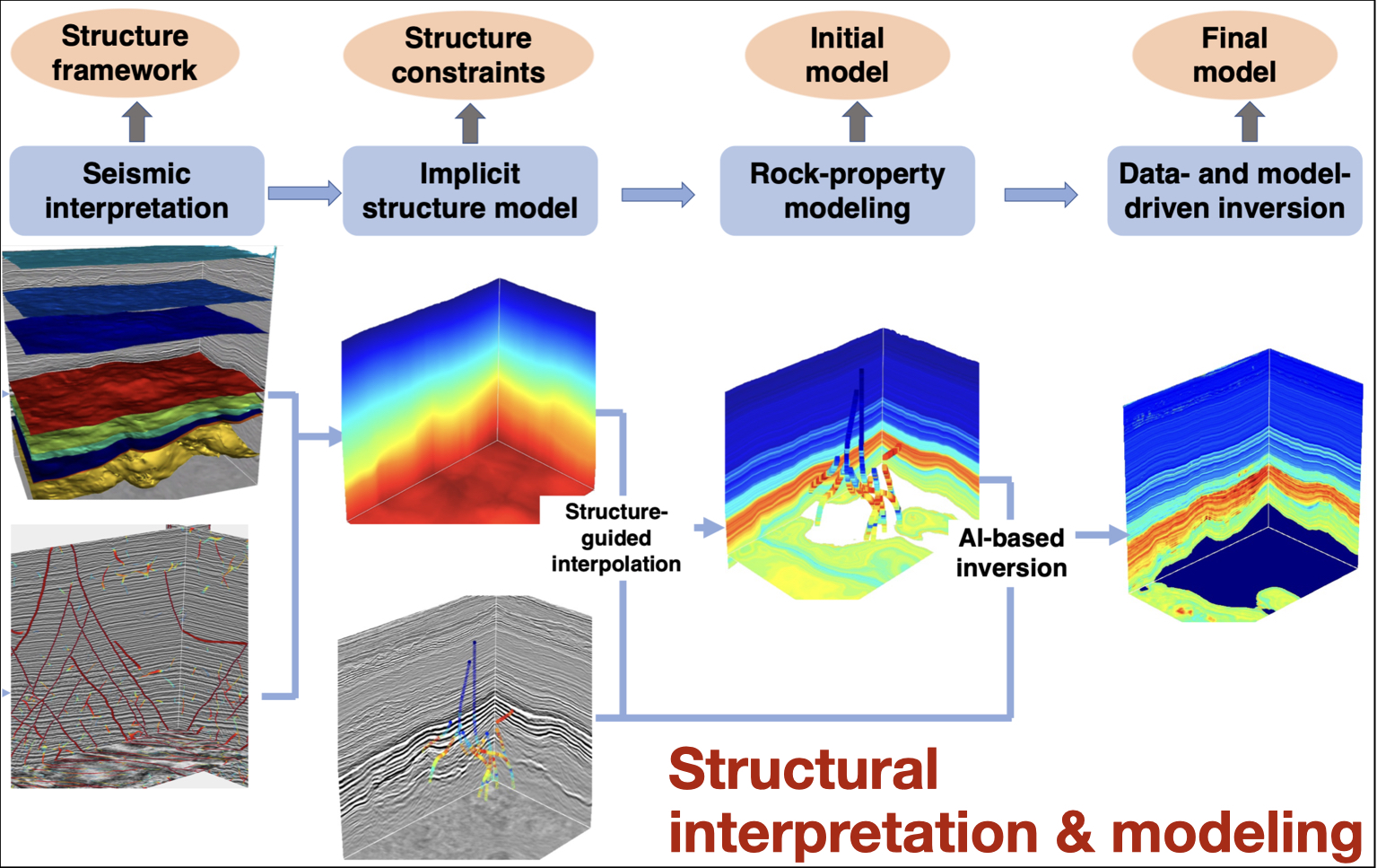
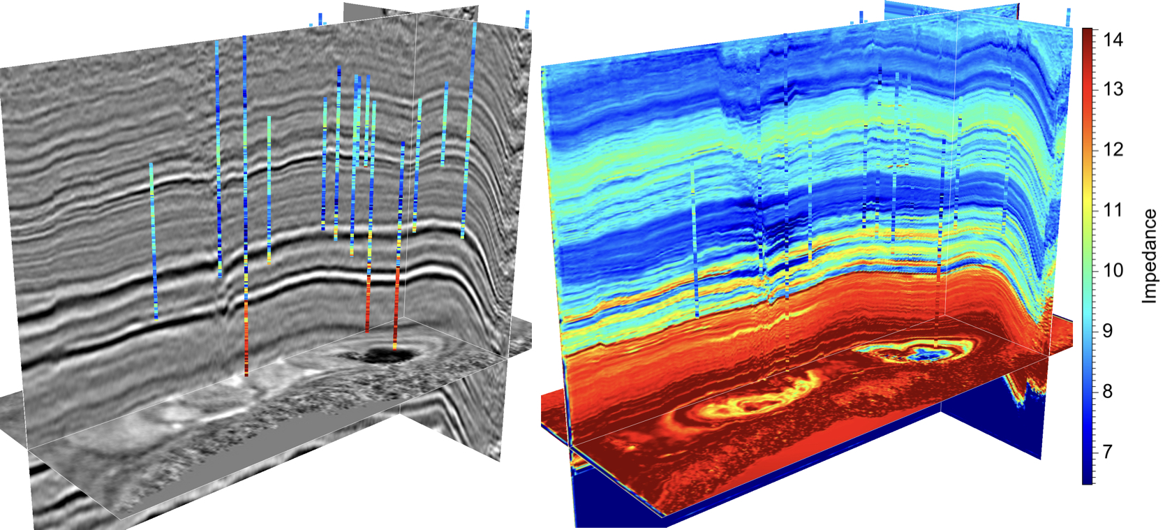
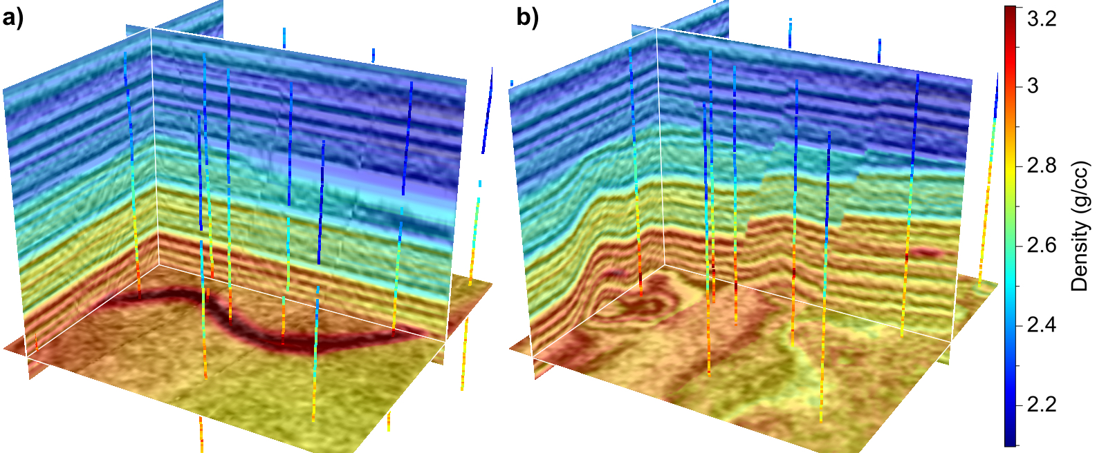
- We present a workflow to fully utilize seismic amplitudes, well-log properties, and interpreted seismic structures to build geologically reasonable models. We first automatically interpret structural features (e.g., faults and horizons) from a 3D seismic image. We then use the interpreted structural features to compute an implicit structural model. We further integrate the provided well-logs and the computed implicit structural model to interpolate a subsurface model that conforms to both well-log properties and seismic structural and stratigraphic features. Finally, we predict a final model with deep learning using seismic and well-log data and meanwhile introduce the initial model as low-frequency constraints into the network. Yan, S., X. Sun, X. Wu*, S. Zhang, and H. Si, 2021, Building subsurface models with horizon-guided interpolation and deep learning: applied to the Volve field. Geophysics, Vol. 87(4), B233–B245. [PDF].
Semi-supervised salt segmentation using mean teacher
Mean teacher 半监督学习与盐丘分割
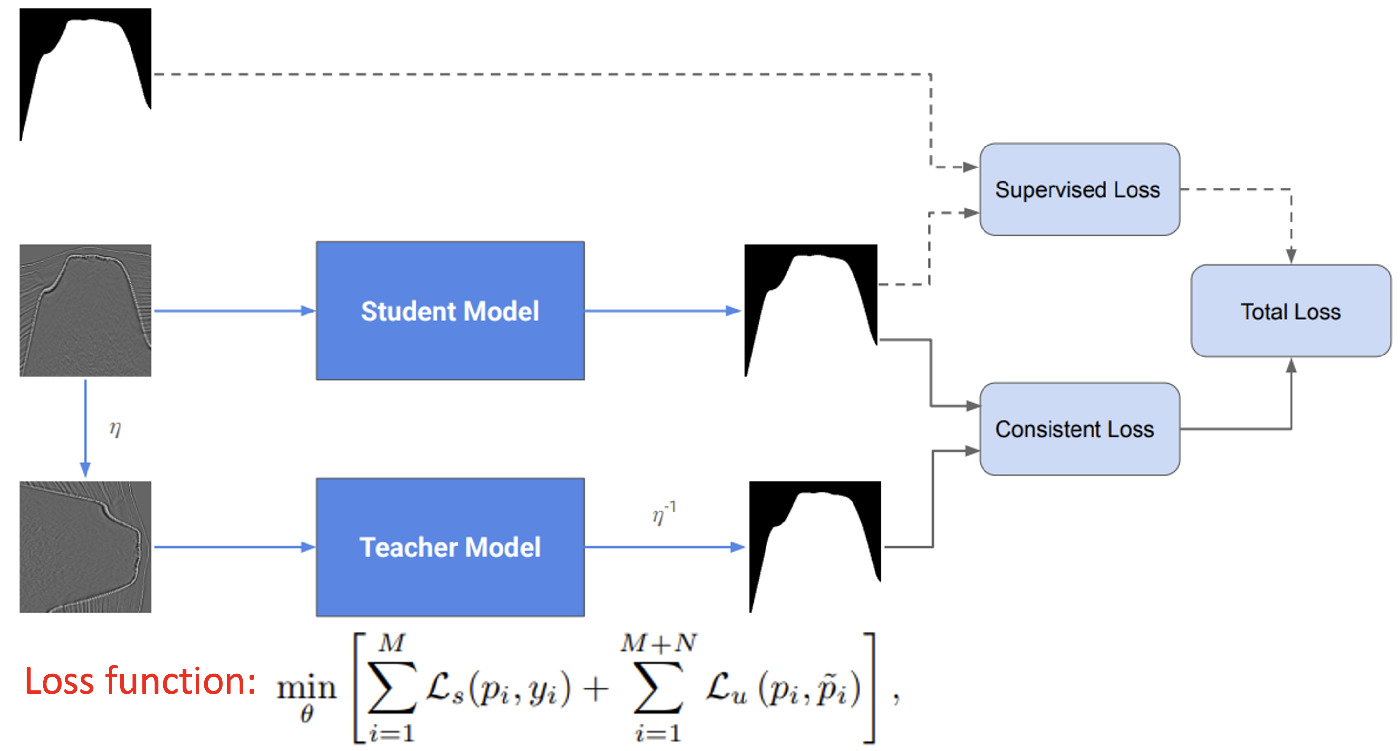
- We propose a semi-supervised framework for salt segmentation, which requires only a small amount of labeled data. We adopt the mean teacher in our semi-supervised method where two models sharing the same network architecture are trained together. The student model is optimized using a combination of supervised loss and unsupervised consistent loss, whereas the teacher model is the exponential moving average (EMA) of the student model. An unsupervised consistent loss is introduced to better extract information from unlabeled data by constraining the network to give consistent predictions for the input data and its perturbed version. We train and validate our novel semi-supervised method on both synthetic and real dataset. Results demonstrate that our proposed semi-supervised salt segmentation method outperforms the supervised method when there is a lack of labeled training data. Geng, Z., Z. Hu, X. Wu*, and S. Fomel 2021, Semi-supervised salt segmentation using mean teacher. Interpretation, Vol. 10(3), SE21-SE29. [PDF].
Deep learning for velocity model building with common-image gathers
基于深度域成像道集的智能速度建模

- The features in the inaccurate common-image gathers (a) migrated from a wrong velocity model (b) are significantly different from those in the accurate gathers (c) migrated from a true velocity model. This means that the residuals of the inaccurate gathers indicate the residuals of the velocity model compared to the true velocity model. We therefore use a deep CNN to analyze the features of inaccurate image gathers to update the initially wrong migration velocity model and obtain a more accurate model (d). Geng, Z., Z. Zhao, Y. Shi, X. Wu, S. Fomel, and M. Sen, 2022, Deep learning for velocity model building with common-image gathers. GJI, 228, 1054–1070. [PDF].
A comparison of deep learning methods for seismic impedance inversion
深度学习波阻抗反演方法对比分析

- We experimentally reveal how network hyperparameters (number of features, kernel sizes, number of layers) and architectures affect the seismic inversion performance, and develop a series of methods which are proven to be effective in reconstructing high-frequency information in the estimated impedance model. Experiments demonstrate that the proposed multi-scale architecture is helpful to reconstruct more high-frequency details than a conventional network. Besides, the reconstruction of high-frequency information can be further promoted by introducing a perceptual loss and a generative adversarial network from the computer vision perspective. More importantly, the experimental results provide valuable references for designing proper network architectures in the seismic inversion problem. Zhang, S., H. Si, X. Wu*, and S. Yan, 2021, A comparison of deep learning methods for seismic impedance inversion. Petroleum Science, Vol. 19(3), 1019-1030. [PDF].
Deep learning for multi-dimensional seismic impedance inversion
基于深度学习的多维波阻抗反演
- Most methods of deep-learning based impedance inversion are based on a 1D neural network which is straightforward to implement but often yields laterally unreasonable discontinuities in predicting a multi-dimensional impedance model trace-by-trace. We improve the deep learning based impedance prediction by implementing it with a multi-dimensional CNN. Synthetic and field examples show that the proposed multi-dimensional CNN is more robust to noise, better recovers thin layers, and yields a laterally more consistent impedance model than a 1D CNN with the same network architecture and the same training logs. Wu, X., S. Yan, Z. Bi, S. Zhang, and H. Si, 2021, Deep learning for multi-dimensional seismic impedance inversion. Geophysics, Vol. 86(5), R735–R745. [PDF].
Kernel prediction network for common image gather stacking
基于预测卷积核的成像道集校正与叠加
- In the pre-stack depth migration, obtaining a high-quality seismic image requires an accurate CIG where the diffractions are focused, the reflection events are flat and the depth of the events are correctly migrated. In practice, such an accurate CIG, however, is hard to obtain due to the errors of acquisition, processing, and the migration velocity model. We propose a kernel prediction neural network (KPN) to flatten the events, correct the depth of the improperly migrated events, and remove the noise and unfocused artifacts in CIGs (lower-left image), and further yield an optimally stacked image (lower-right image). Li, Z., X. Wu*, P. Zhu, L. Liang, W. Cai, H. Zhang, and Z. Liao, 2025, Kernel prediction network for common image gather stacking . SEG, accepted, IEEE TGRS, Vol. 63, 5907514. [PDF]
Deep learning for simultaneous seismic super-resolution and denoising
基于深度学习的地震数据同时超分与去噪处理
- This work is done by Jintao Li (李金涛), a senior college student at University of Science and Technology of China. He is joining CIG in Fall, 2020.
- We propose a deep learning method to simultaneously improve the resolution of an input seismic image (a) and attenuate potential noise in the seismic, which allows us to obtain an output (b) with clearer and more detailed features (e.g., thin layers and sharp faults with small throws). Li, J., X. Wu* and Z. Hu, 2021, Deep learning for simultaneous seismic super-resolution and denoising. IEEE TGRS, Vol. 60, pp. 1-11, [PDF]. [CODE]. (Highly cited paper)
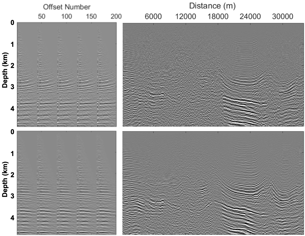
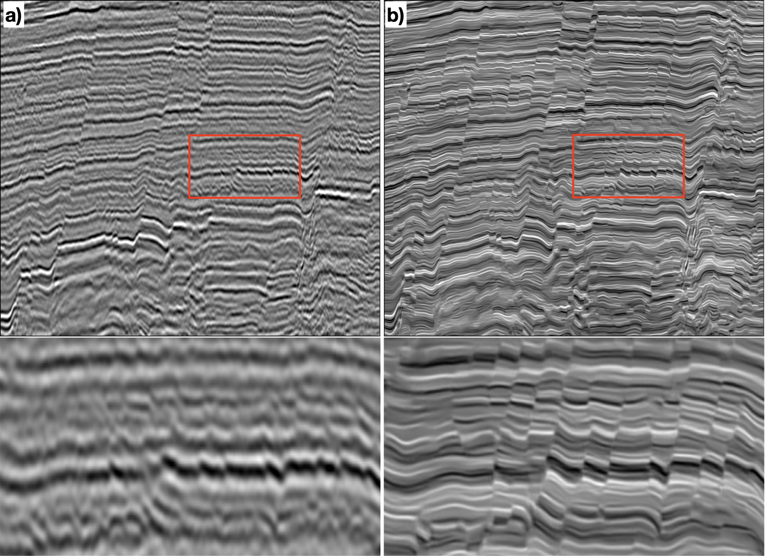
Wavelet estimation and non-stretching NMO correction
地震子波估计与无畸变动校正
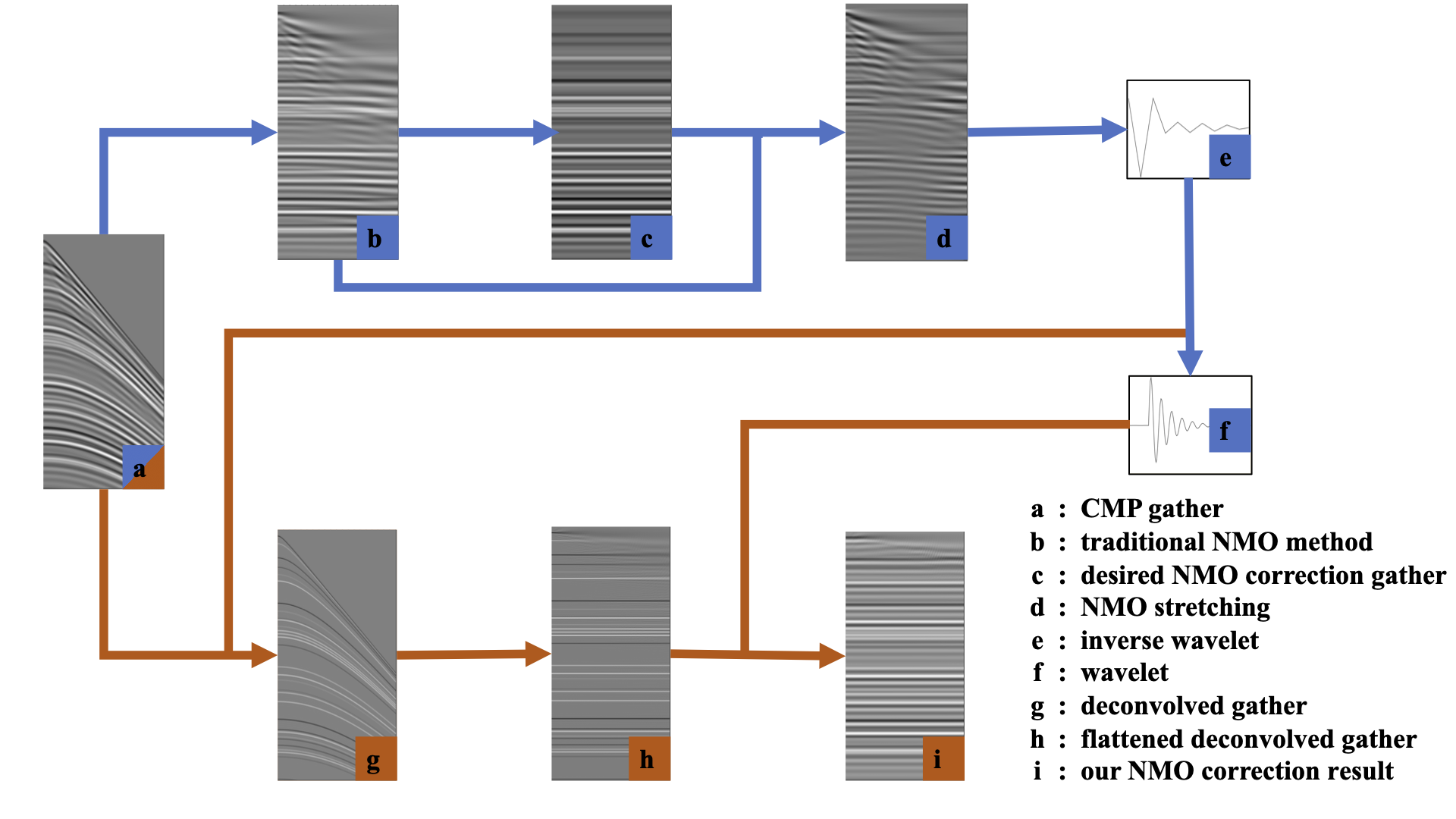

- This work is done by Hanlin (绳瀚林), a senior college student at University of Science and Technology of China. He is joining CIG in Fall, 2020.
- We propose a workflow (left image) for wavelet estimation and non-stretching NMO correction. In this workflow, we first estimate a wavelet based on the waveform stretching in the NMO correction. Secondly, we deconvolve the original CMP gather based on the estimated wavelet. Thirdly, we apply an improved NMO correction to the deconvolved CMP gather and obtain flattened reflectivities. We finally convolve the flattened and deconvolved gather with the estimated wavelet back to obtain a NMO-corrected gather without stretching artifacts. Sheng, H., X. Wu* and B. Zhang, 2022, Wavelet estimation and NMO correction. Geophysics, Vol. 87(3), V193–V203. [PDF].
Channel simulation and deep learning for channel interpretation in 3D seismic images
三维河道数值模拟与地震数据中河道体的智能识别
- This work is done by Hang Gao (高航), a senior college student at China University of Geosciences (Beijing). He is joining CIG in Fall, 2020.
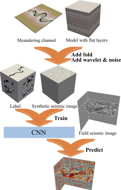
- In this work, we propose a workflow to first numerically simulate meandering channel systems which are then integrated with folding structures to build realistic structural models. With such models, we are able to automatically generate numerous training seismic images and the corresponding channel labels. We consider the channel characterization in 3D seismic images as an image segmentation problem and design a 3D convolutional neural network (CNN) for the channel segmentation. We train the CNN by using synthetic datasets that are generated by using the proposed simulation workflow. The trained CNN works well to detect the meandering channel systems in field seismic images. Gao, H., X. Wu* and G. Liu, 2021, ChannelSeg3D: channel simulation and deep learning for channel interpretation in 3D seismic images. Geophysics, Vol. 86(4), IM73–IM83. [PDF]. [CODE].
Deep learning for paleokarst delineation
古岩溶溶洞智能识别
- This is a great collaboration with international researchers including Dr. Jie Qi from University of Oklahoma and Dr. Hongliu Zeng from the Bureau of Economic Geology.
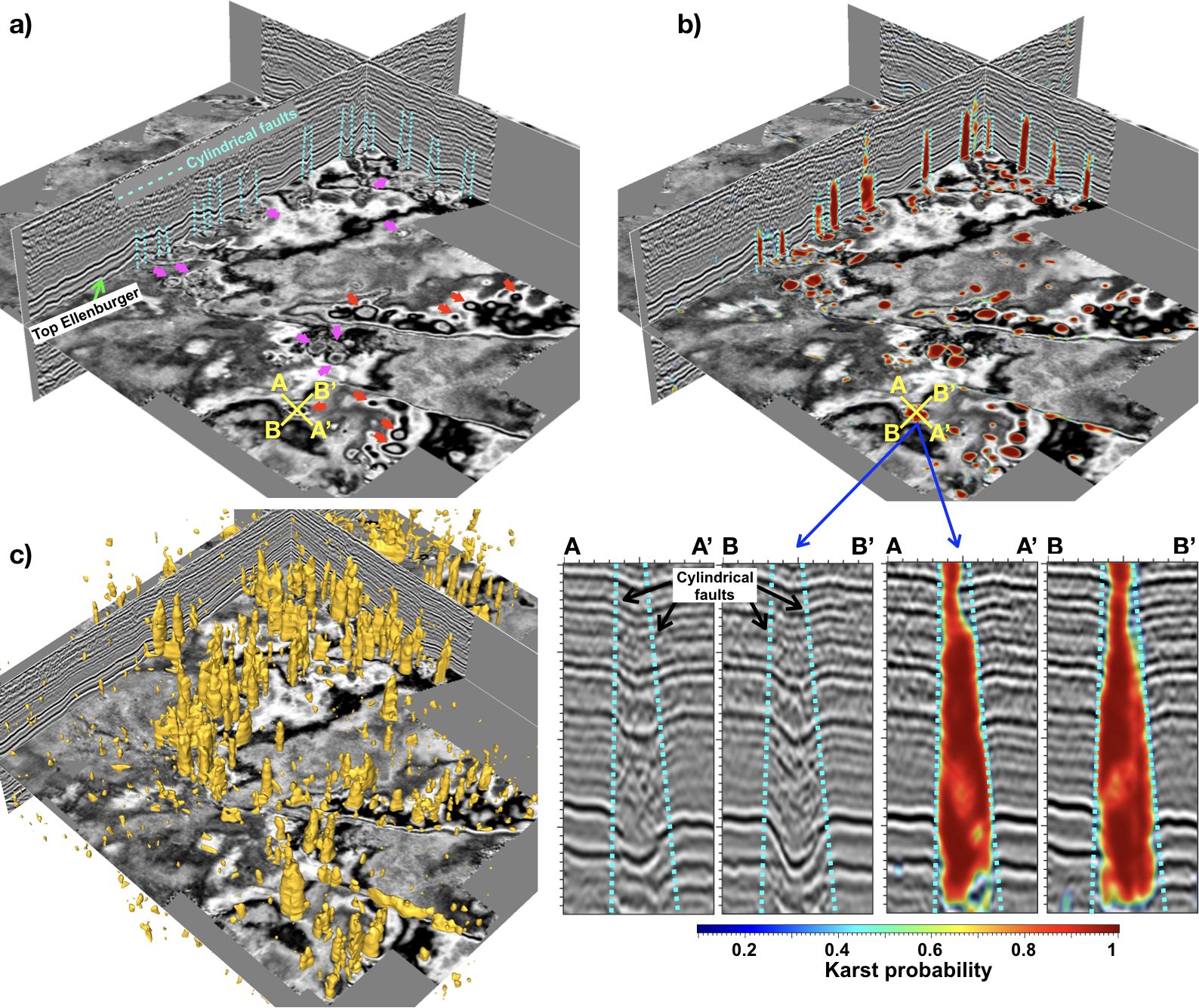
- In this work, we propose a workflow to simulate realistic structural features of folding and paleokarst systems in 3D seismic images. We consider the paleokarst delineation in 3D seismic images as an image segmentation problem and design a deep convolutional neural network (CNN) for the paleokarst segmentation. We train the CNN by using synthetic datasets that are generated by using the proposed simulation workflow. The trained CNN works well to detect the paleokarst features in field seismic images (a) by computing a probability image (b), from which we are able to automatically extract the 3D paleokarst systems (c). Wu, X., S. Yan, J. Qi, and H. Zeng, 2020, Seismic simulation of paleokarst systems and deep learning for characterizing paleokarst features in 3D seismic images. JGR, Solid Earth, Vol. 125(9), 1-23, e2020JB019685. [PDF]
Numerical modeling of channels
- In order to understand the development of the channel systems, we have been working on the numerical simulation of meandering and delta channels. The cartoons on the left are Hang Gao's research with CIG. Hang Gao is currently a senior at China University of Geosciences (Beijing). He is joining CIG as a graduate student in the Fall of 2020. updated on Dec. 8th, 2019...
Multi-task learning for seismic image processing
基于多任务学习的地震图像处理
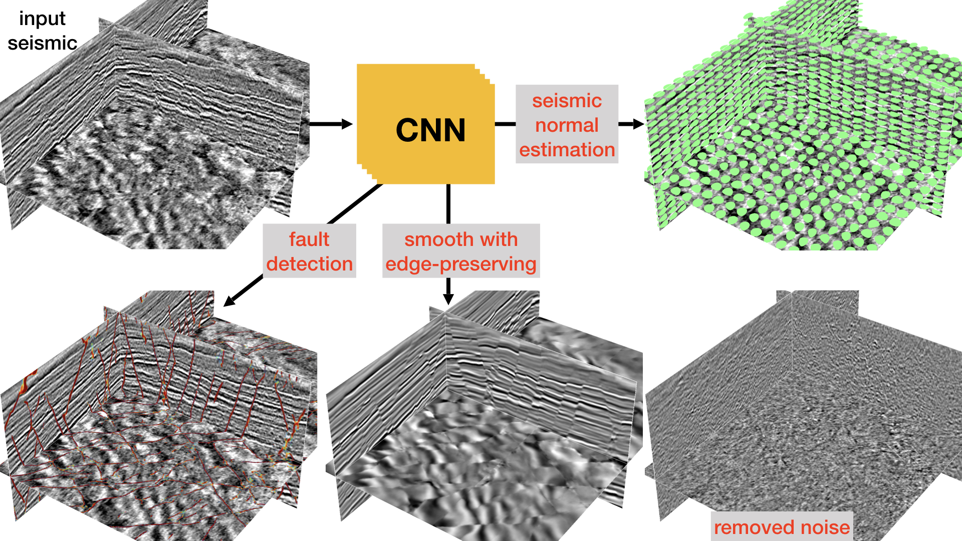
-
We design a single convolutional neural network to simultaneously perform three image processing tasks:
- compute a clean and sharp fault image
- estimate a seismic normal vector field
- compute a smoothed seismic image with enhanced reflections and sharpened faults while noise removed
Wu, X., L. Liang, Y. Shi, Z. Geng and S. Fomel, 2019, Multi-task learning for local seismic image processing: fault detection, structure-oriented smoothing with edge-preserving, and seismic normal estimation by using a single CNN. GJI, Vol. 210(3), 2097-2109.
[PDF]
Building realistic structure models
基于多任务学习的地震图像处理

-
We propose a workflow to automatically build diverse structure models with realistic folding and faulting features.
In this workflow, with some assumptions about typical folding and faulting patterns, we simulate structural features
in a 3D model by using a set of parameters. By randomly choosing the parameters from some predefined ranges,
we are able to automatically generate numerous structure models with realistic and diverse structural features.
Based on these structure models with known structural information, we further automatically create numerous
synthetic seismic images and the corresponding ground truth of structural labels to train CNNs for structural
interpretation in field seismic images. Accurate results of structural interpretation in multiple field seismic
images show that the proposed workflow simulates realistic and generalized structure models from which
the CNNs effectively learn to recognize real structures in field images.
- Wu, X., Z. Geng, Y. Shi, N. Pham, S. Fomel, and G. Caumon, 2019, Building realistic structure models to train convolutional neural networks for seismic structural interpretation. Geophysics, Vol. 85(4), WA27-WA39. [PDF]
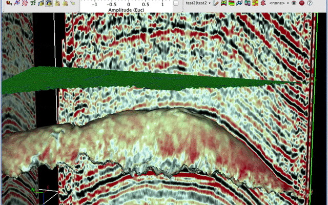
Deep learning flood-filling network

- We design a deep learning workflow to interactively track seismic geobodies, such as salt bodies and faults. The algorithm is based on a flood-filling network, which performs iterative segmentation and moving the field of view (FoV). Instead of an end-to-end segmentation from the image to the classification mask, the proposed network takes the previous mask output, together with the seismic image in a new FoV, as a combined input to predict the mask at this FoV. The movement of the FoV is guided by the flood-filling algorithm in order to visit and segment the full extent of a geobody. Unlike the conventional seismic image segmentation methods that can only output attribute volumes, the proposed workflow can not only detect geobodies but also track individual geobody instances. Shi, Y. and X. Wu*, 2019, Interactive tracking of seismic geobodies using deep learning flood-filling network. Geophysics, Vol. 86(1), A1-A5. [PDF]
Forward simulation of geologic process

- We have been working on forward numerical simulation of various geologic processes, which would be helpful for our geologic understanding or interpretation of geophysical datasets. This cartoon shows a simple implementation of 2D stratigraphic modeling.
Deep learning for estimating RGT and horizons
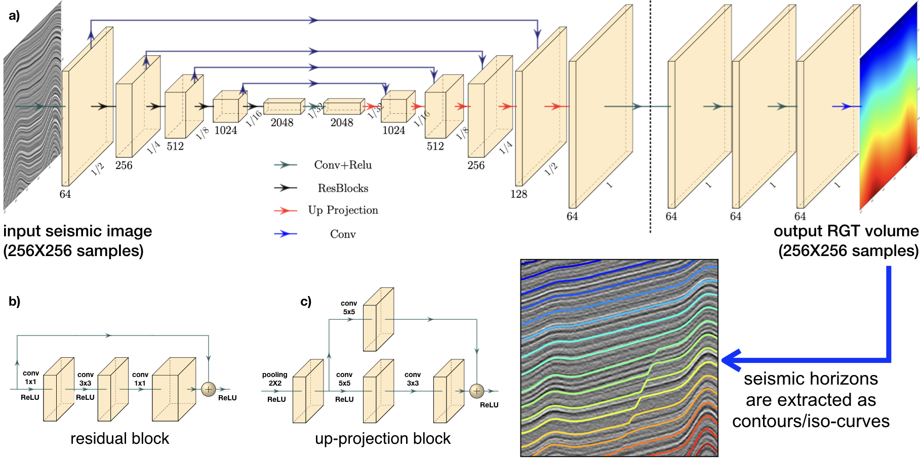
- Constructing a Relative Geologic Time (RGT) image from a seismic image is crucial for seismic structural and stratigraphic interpretation. In conventional methods, automatic RGT estimation from a seismic image is typically based on only local image features, which makes discontinuous structures (e.g., faults and unconformities) challenging to cope with. We consider the estimation of 2D RGT images as a regression problem, where we design a deep convolutional neural network (CNN) to directly and automatically compute an RGT image from a 2D seismic image. This CNN consists of three parts: an encoder, a decoder and a refinement module. We train this CNN by using 2080 pairs of synthetic input seismic images and target RGT images and then test it on 960 testing seismic images. Although trained with only synthetic images, the network can generate accurate results on real seismic images. Multiple field examples show that our CNN-based method is significantly superior to conventional methods, especially in dealing with complex structures such as crossing faults and complicatedly folded horizons, without the need of any manual picking.
- Geng, Z., X. Wu*, Y. Shi, S. Fomel, 2019, Deep learning for relative geologic time and seismic horizons. Geophysics, Vol. 85(4), WA87–WA100. [PDF].
Waveform embedding with unsupervised deep learning
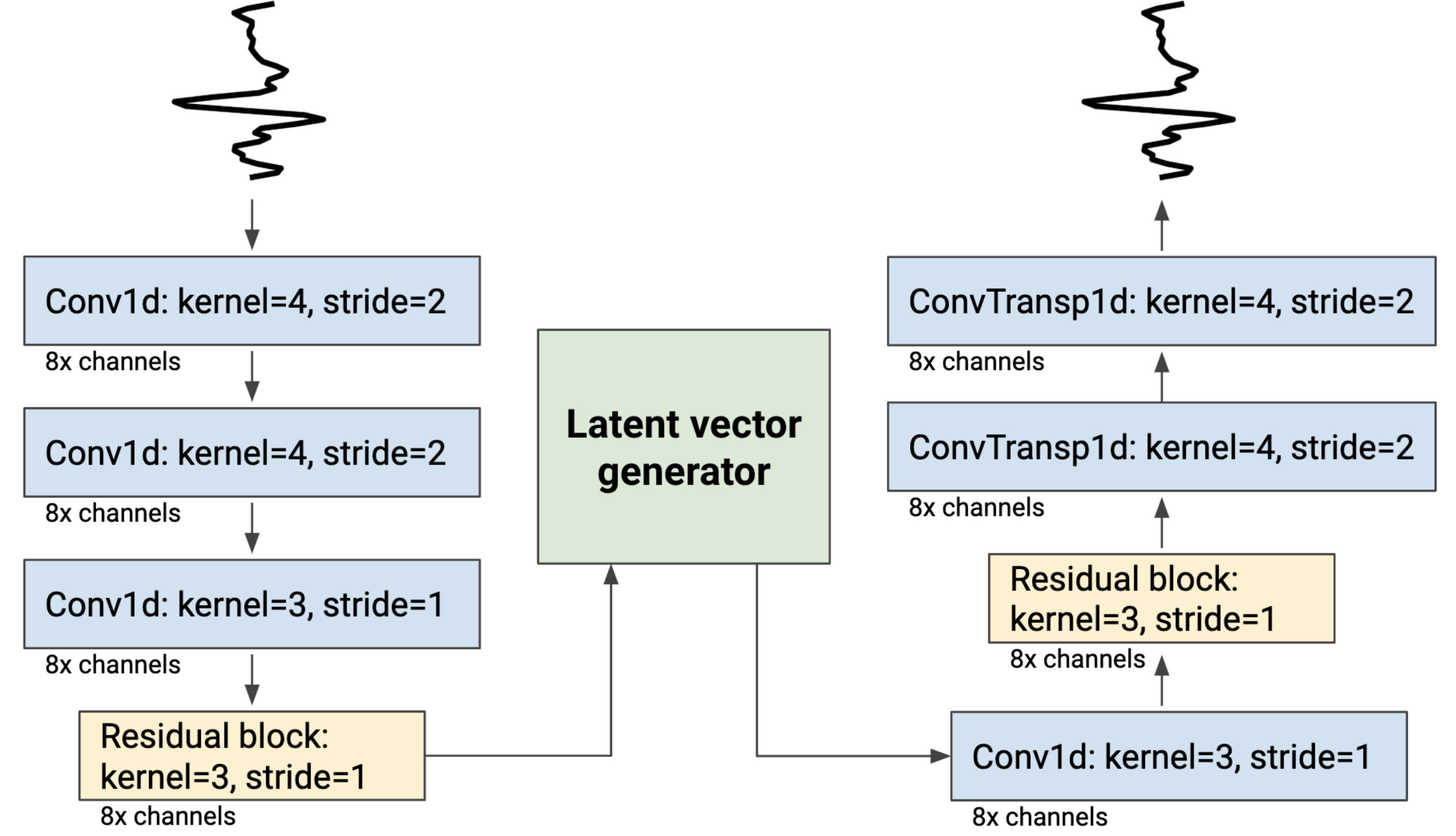
- We propose an unsupervised approach, Waveform Embedding, based on a deep convolutional autoencoder network to learn to transform seismic waveform samples to a latent space in which any waveform can be represented as an embedded vector. The regularizing mechanism of the autoencoder ensures that similar waveform patterns are mapped to embedded vectors with shorter distance in the latent space. Within a search region, we transform all the waveform samples to latent space and compute their corresponding distance to the embedded vector of a control point that is set to the target horizon; we then convert the distance to a horizon probability map that highlights where the horizon is likely to be located. labels.
- Shi, Y., X. Wu*, and S. Fomel, 2020, Waveform embedding: automatic horizon picking with unsupervised deep learning. Geophysics, Vol. 85(4), WA67–WA76. [PDF].
Convolutional long short-term memory network
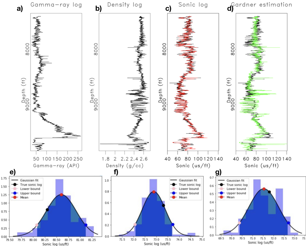
-
We propose a method to estimate missing well logs by using a bidirectional convolutional long short-term memory (bidirectional ConvLSTM)
cascaded with fully connected neural networks (FCNNs). We train the model on 177 wells from mature areas of the UK continental shelf (UKCS).
We test the trained model on one blind well from UKCS, three wells from the Volve field in the Norwegian continental shelf (NCS), and one well
from the Penobscot field in the Scotian shelf offshore Canada. The method takes into account the depth trend and the local shape of logs by
using LSTM and convolutional architecture. The method is examined on sonic log prediction and can produce an accurate prediction of
sonic logs from gamma-ray and density logs. The advantages of our method are that it is not applied on an interval by interval basis like
rock physics based methods and it also outputs the uncertainties facilitated by a dropout layer and Monte-Carlo sampling at inference time.
- Pham, N., X. Wu*, and E. Naeini, 2020, Missing well log prediction using convolutional long short-term memory network. Geophysics, Vol. 85(4), WA159–WA171. [PDF].
FaultSeg3D: Using synthetic data sets to train a CNN for 3D seismic fault segmentation
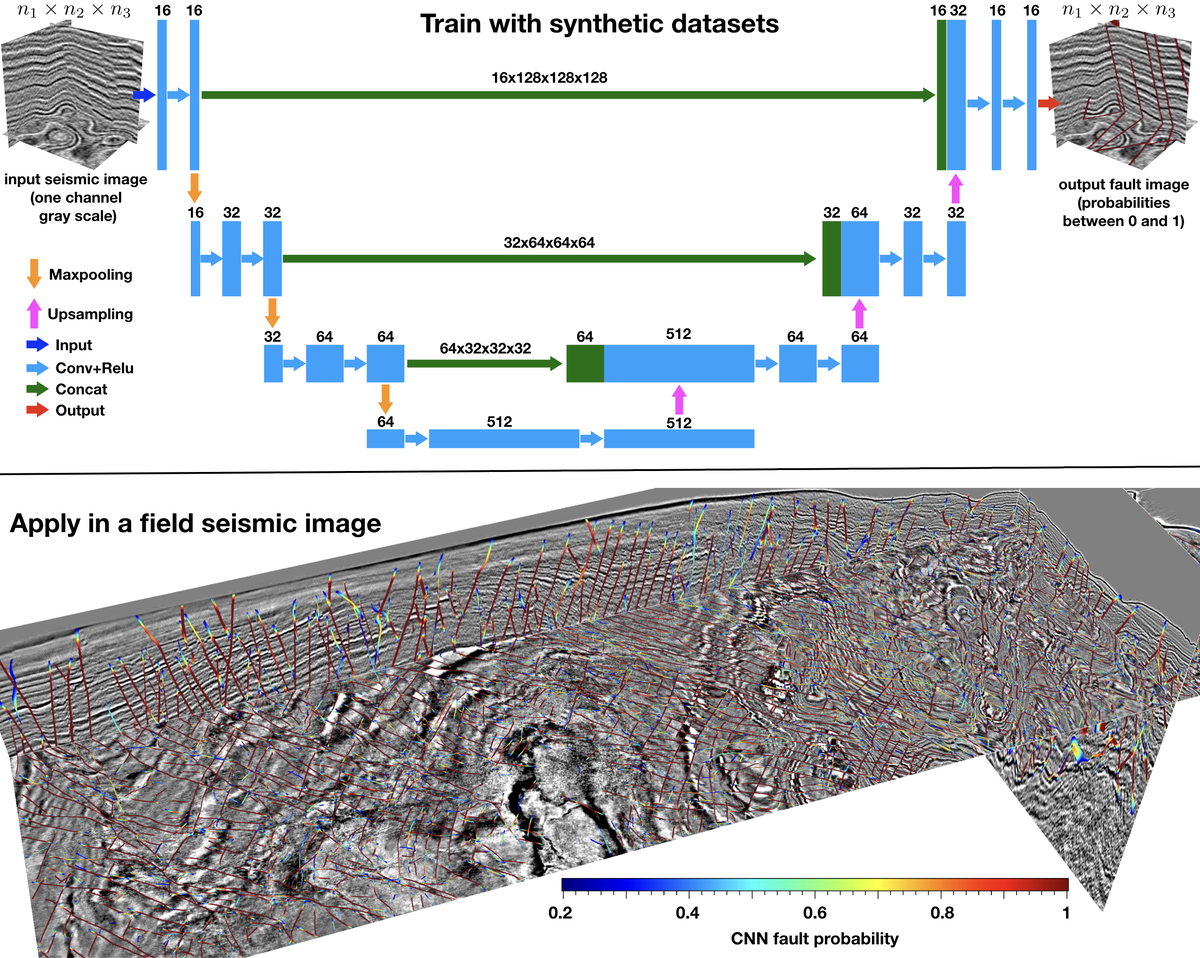
- We consider fault detection as a binary image segmentation problem of labeling a 3D seismic image with ones on faults and zeros else- where. We have performed an efficient image-to-image fault segmentation using a supervised fully convolutional neural network. To train the network, we automatically create 200 3D synthetic seismic images and corresponding binary fault labeling images, which are shown to be sufficient to train a good fault segmentation network. After training with only the synthetic data sets, the network automatically learns to calculate rich and proper features that are important for fault detection. Multiple field examples indicate that the neural network (trained by only synthetic data sets) can predict faults from 3D seismic images much more accurately and efficiently than conventional methods.
- Wu, X., L. Liang, Y. Shi and S. Fomel, 2019, FaultSeg3D: using synthetic datasets to train an end-to-end convolutional neural network for 3D seismic fault segmentation. Geophysics, Vol. 84(3), IM35-IM45. [PDF] [CODE]. (Highly cited paper)
FaultNet3D: predicting fault probabilities, strikes, and dips with a single CNN
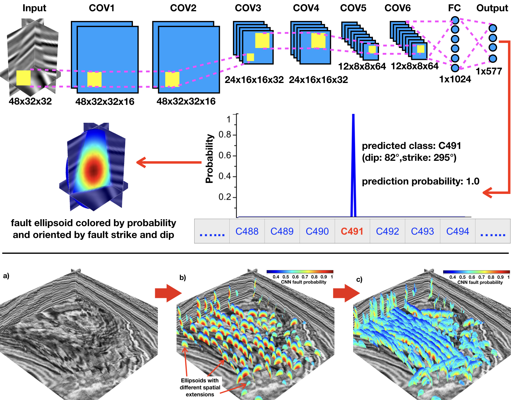
- We simultaneously estimate fault probabilities, strikes, and dips directly from a seismic image by using a single convolutional neural network (CNN). In this method, we assume a local 3-D fault is a plane defined by a single combination of strike and dip angles. We assume the fault strikes and dips, respectively, are in the ranges of [0°, 360°) and [64°, 85°], which are divided into 577 classes corresponding to the situation of no fault and 576 different combinations of strikes and dips. We construct a 7-layer CNN to classify the fault strike and dip in a local seismic cube and obtain the classification probability at the same time. With the fault probability, strike and dip estimated at some seismic pixel, we further compute a fault cube (centered at the pixel) with fault features elongated along the fault plane. By sliding the classification window within a full seismic image, we are able to obtain a lot of overlapping fault cubes which are stacked to compute three full images of enhanced and continuous fault probabilities, strikes, and dips.
- Wu, X., Y. Shi, S. Fomel, L. Liang, Q. Zhang and A. Yusifov, 2019, FaultNet3D: predicting fault probabilities, strikes and dips with a single convolutional neural network. IEEE TGRS, Vol. 57(11), 9138-9155. [PDF]
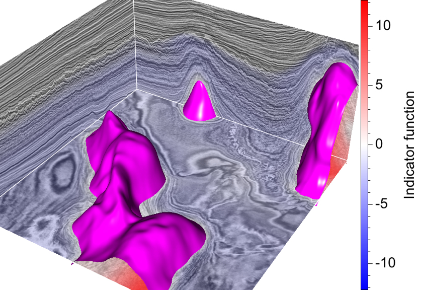
SaltSeg: automatic 3D salt segmentation using a deep CNN
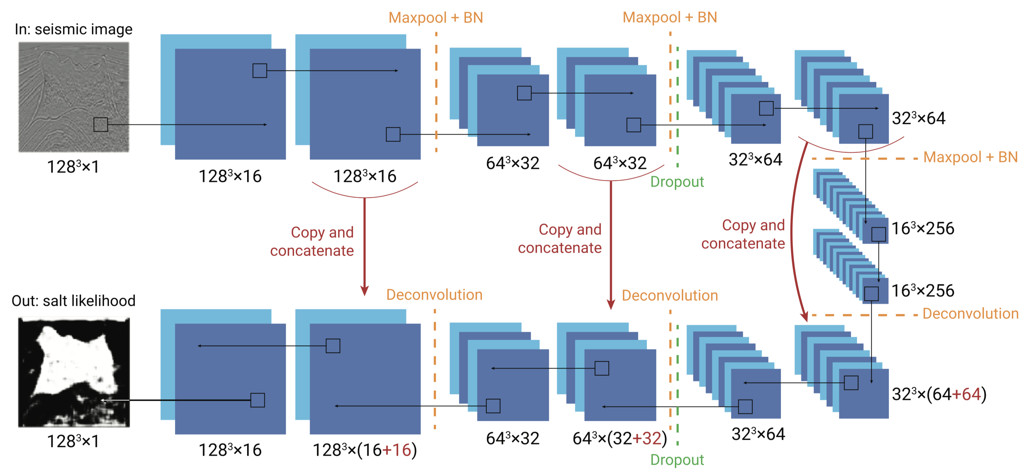
- We have formulated the problem as 3D image segmentation and evaluated an efficient approach based on deep convolutional neural networks (CNNs) with an encoder-decoder architecture. To train the model, we design a data generator that extracts randomly positioned sub-volumes from large-scale 3D training data set followed by data augmentation, then feed a large number of sub-volumes into the network while using salt/nonsalt binary labels generated by thresholding the velocity model as ground truth labels. We test the model on validation data sets and compare the blind test predictions with the ground truth. Our results indicate that our method is capable of automatically capturing subtle salt features from the 3D seismic image with less or no need for manual input. We further test the model on a field example to indicate the generalization of this deep CNN method across different data sets.
- Shi, Y., X. Wu* and S. Fomel, 2019, SaltSeg: Automatic 3D salt body segmentation using a deep convolutional neural network. Interpretation, SE113-SE122. [PDF]
Normal fault populations in the Costa Rica Margin
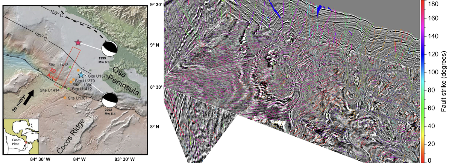
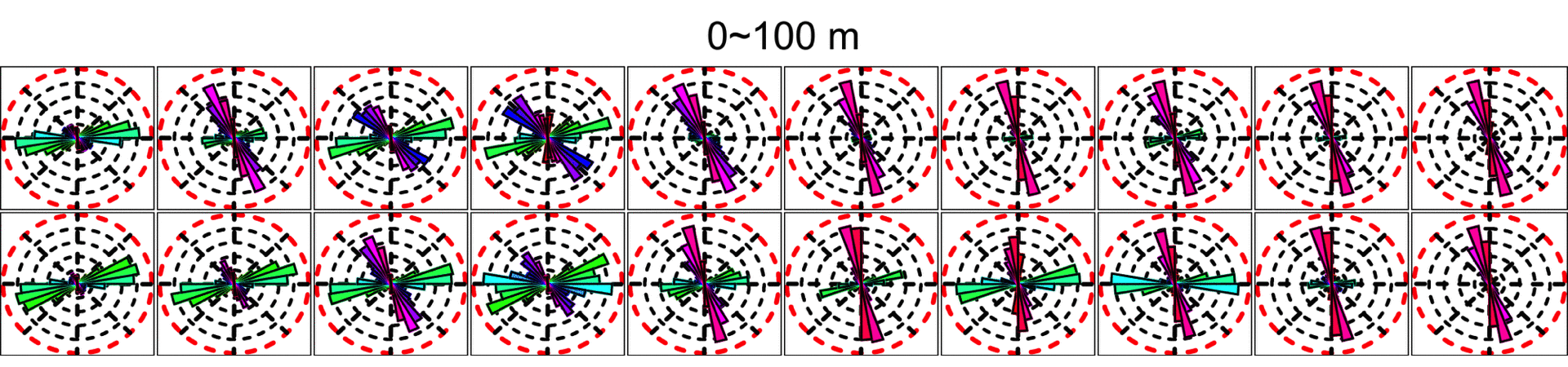
- From the 3D seismic image (right above) acquired in Costa Rica subduction area (left above), we automatically compute more than 10 thousands 3D fault surfaces and their strikes, dips, and slips. With these computed high-resolution fault positions and strikes, we are able to make the “blooming roses” (the cartoon below) to visualize the fault-strike variations with depth (or geologic time) and space.
Optimal surface voting
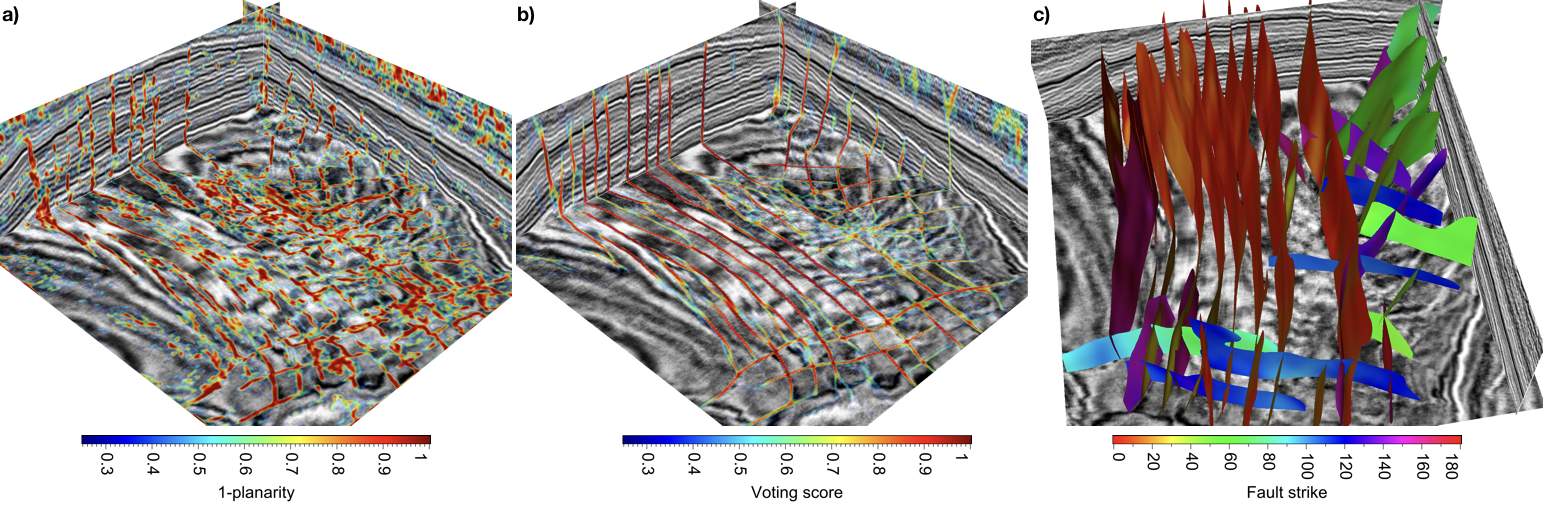
- We proposed a method to automatically pick optimal surfaces from an input fault attribute image (a) and use the surfaces to vote for an enhanced fault image (b), from which we further automatically construct fault surfaces (c). Our parallel implementation of this method takes only seconds for this example.
- Wu, X. and S. Fomel, 2018, Automatic fault interpretation with optimal surface voting. Geophysics, Vol. 83(5), O67-O82. [PDF] [CODE]
The corresponding software package has been widely used in industry. One of xinming's favorite work
Least-squares horizons
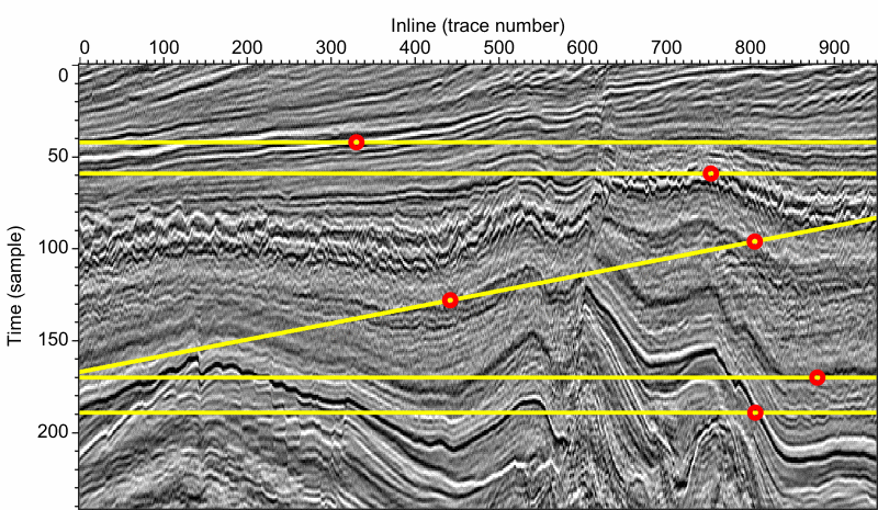
- We have developed a novel method to compute horizons that globally fit the local slopes and multigrid correlations of seismic traces. In this method, we first estimate local reflection slopes by using structure tensors and compute laterally multigrid slopes by using dynamic time warping (DTW) to correlate seismic traces within multiple laterally coarse grids. These coarse-grid slopes can correctly correlate reflections that may be significantly dislocated by faults or other discontinuous structures. Then, we compute a horizon by fitting, in the least-squares sense, the slopes of the horizon with the local reflection slopes and multigrid slopes or correlations computed by DTW.
- Wu, X. and S. Fomel, 2018, Least-squares horizons with local slopes and multi-grid correlations, Geophysics, Vol. 83(4), IM29–IM40. [PDF] [CODE]
- Best Paper, Honorable Mention, 2018
Interactive salt boundary picking
- In this method, we first pick a few points to interpolate an initial curve that is close to the true salt boundary. These points are picked near the salt boundary but are not required to be exactly on the boundary, which makes human interactions convenient and efficient. We then resample the envelope image in a band area centered at the initial curve to obtain a new image where the true salt boundary is an open curve extending from left to right. We then extract the salt boundary in the new image using an optimal-path picking algorithm, which is robust to track a highly discontinuous salt boundary by picking the optimal path with globally maximum envelope values. We finally map the picked path back to the original image to obtain a final salt boundary.
- Wu, X., S. Fomel, and M. Hudec, 2018, Fast salt boundary interpretation with optimal path picking. Geophysics, Vol. 83(3), O45–O53. [PDF] [CODE]
Incremental correlation of well logs
- In this method, we first automatically compute an optimal path that starts with longer logs and follows geologically more continuous structures. We then use the dynamic warping technique to sequentially correlate the logs following the path. To avoid potential error propagation with the path, we modify the dynamic warping algorithm to use all the previously correlated logs as references to correlate the current log in the path. During the sequential correlations, we compute geologic distances between the current log and all the reference logs. Such distances are proportional to Euclidean distances but increase dramatically across discontinuous structures such as faults and unconformities that separate the current log from the reference logs. We also compute correlation confidences to provide quantitatively quality control of the correlation results. We use both the geologic distances and correlation confidences to weight the references in correlating the current log.
- Wu, X., Y. Shi, S. Fomel, and F. Li, 2018, Incremental correlation of multiple well logs following geologically optimal neighbors. Interpretation, Vol. 6(3), T713–T722. [PDF]
Regularization in geophysical inversion
- Geophysical inversion is often ill-posed because of inaccurate and insufficient data. Regularization is often applied to the inversion problem to obtain a stable solution by imposing additional constraints on the model. Common regularization schemes impose isotropic smoothness on solutions and may have difficulties in obtaining geologically reasonable models that are often supposed to be anisotropic and conform to subsurface structural and stratigraphic features. Xinming introduces a general method to incorporate constraints of seismic structural and stratigraphic orientations and fault slips into geophysical inversion problems. He first uses a migrated seismic image to estimate structural and stratigraphic orientations and fault slip vectors that correlate fault blocks on opposite sides of a fault. He then uses the estimated orientations and fault slips to construct simple and convenient anisotropic regularization operators in inversion problems to spread information along structural and stratigraphic orientations and across faults. In this way, we are able to compute inverted models that conform to seismic reflectors, faults, and stratigraphic features such as channels. The regularization is also helpful to integrate well-log properties into the inversion by spreading the measured rock properties away from the well-log positions into the whole inverted model across faults and along structural and stratigraphic orientations.
- Wu, X., 2017, Structure-, stratigraphy-, and fault-guided regularization in geophysical inversion. Geophysical Journal International, Vol. 210(1), 184-195. [PDF]
Simultaneous multiple well-seismic ties
- Most methods tie multiple wells to seismic data one-by-one, hence do not guarantee lateral consistency among multiple well ties. We propose to simultaneously tie multiple wells by first flattening synthetic and real seismograms so that all seismic reflectors are horizontally aligned. By doing this, we turn multiple well-seismic tying into a 1D correlation problem. We then simply compute only vertically-variant but laterally-constant shifts to correlate these horizontally aligned (flattened) synthetic and real seismograms. This two-step correlation method maintains lateral consistency among multiple well ties by computing a laterally and vertically optimized correlation of all synthetic and real seismograms.
- Wu, X. and G. Caumon, 2017, Simultaneous multiple well-seismic ties with flattened synthetic and real seismograms. Geophysics, Vol. 82(1), IM13-IM20. [PDF]
Subsurface modeling
- Xinming proposed an automatic method to fully use both seismic and borehole data to build subsurface models that honor borehole measurements and conform to seismic horizons, faults, unconformities, and stratigraphic features such as channels. In this method, he first automatically removes the faulting and folding in both seismic and borehole data and map them into a flattened space, in which seismic reflectors and borehole measurements corresponding to the same geologic layers are horizontally aligned. He then builds a subsurface model in this flattened space by computing a sequence of 2D horizontal interpolations of well logs. Each horizontal interpolation is guided by the stratigraphic features apparent in the corresponding horizontal seismic slice, so that the interpolant conforms to the seismic stratigraphic features. He finally maps the interpolated model back into the input space and obtain a subsurface model that honors both the seismic and borehole data.
- Wu, X., 2017, Building 3D subsurface models conforming to seismic structural and stratigraphic features. Geophysics, Vol.82(3), IM21-IM30. [PDF]
Structure- and stratigraphy-oriented smoothing

- We proposed a method to efficiently enhance seismic reflections, faults, and channels in a 3D seismic image while at the same time computing a mapping of faults and channels.
- Wu, X. and Z. Guo, 2019, Detecting faults and channels while enhancing seismic structural and stratigraphic features. Interpretation, Vol. 7(1), T155–T166. [PDF] [CODE]
Estimating seismic structural and stratigraphic orientations
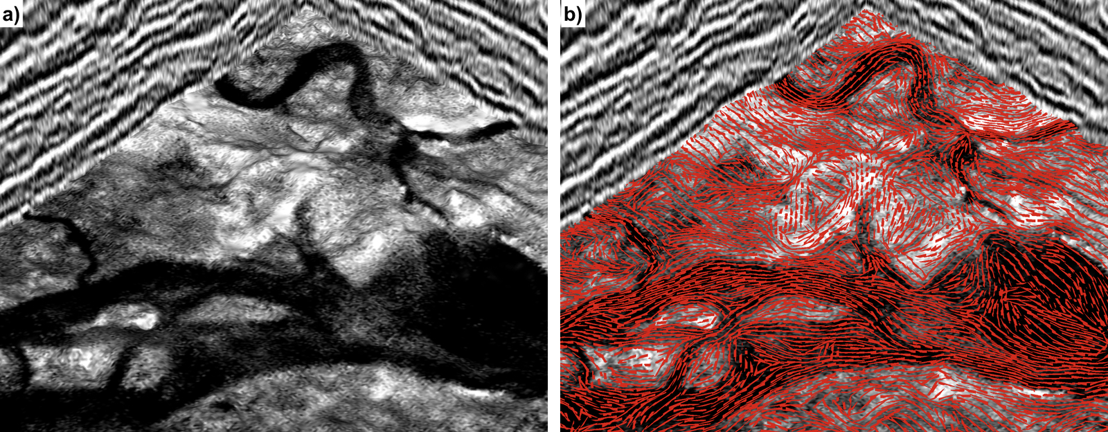
- Conventional structure-tensor method often generates significant errors in estimating orientations of the reflections with steep and rapidly varying slopes. To better estimate reflection orientations, we propose to construct structure tensors in a new space, where the reflections are mostly flat or only slightly dipping and the variation of reflection slopes is reduced. We use these constructed structure tensors to compute reflection normals in this new space and then transform the normals back to obtain a better estimation of reflection orientations in the original space. Seismic stratigraphic features such as channels are often aligned within dipping reflections. It is not discussed previously by others to estimate orientations of such features directly from a seismic image. An ideal way to estimate stratigraphic orientations is to first extract a horizon surface with stratigraphic features, and then construct structure tensors with gradients on the surface to estimate the orientations of the features. However, extracting horizon surfaces can be a difficult and time-consuming task in practice. Fortunately, computing gradients on a horizon surface is only a local operation and is equivalent to directly compute directional derivatives along reflection slopes without picking horizons. Based on this observation, we propose to use an equivalent but more efficient way to estimate seismic stratigraphic orientations by using structure tensors constructed with the directional derivatives along reflections.
- Wu, X. and X., Janson, 2017, Directional structure tensors in estimating seismic structural and stratigraphic orientations. Geophysical Journal International, Vol. 210(1), 534-548. [PDF]
Enhanced coherence
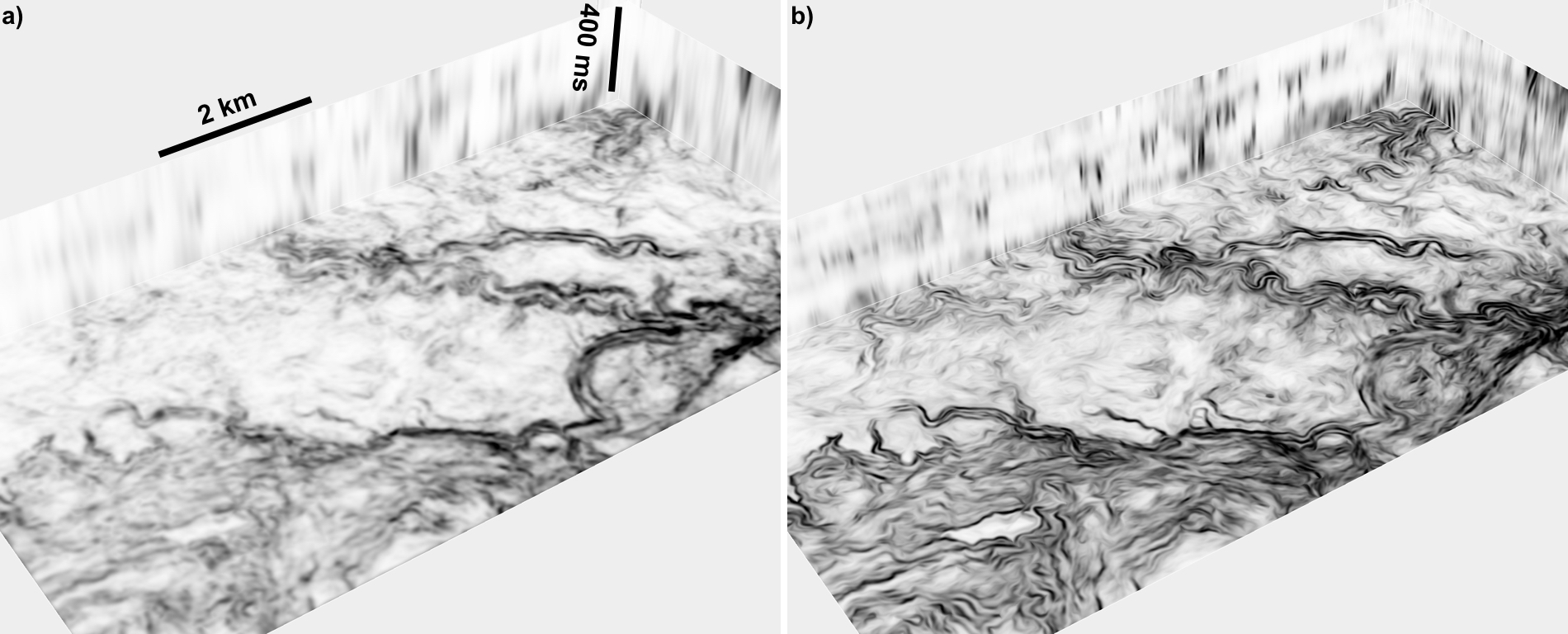
- A coherence image can be computed from the eigenvalues of conventional structure tenors, which are outer products of gradients of a seismic image. Xinming proposes a simple but effective method to improve such a coherence image by using directional structure tensors, which are different from the conventional structure tensors in only two aspects. Firstly, instead of using image gradients with vertical and horizontal derivatives, he uses directional derivatives, computed in directions perpendicular and parallel to seismic structures (reflectors), to construct directional structure tensors. With these directional derivatives, lateral seismic discontinuities, especially those subtle stratigraphic features aligned within dipping structures, can be better captured in the structure tensors. Secondly, instead of applying Gaussian smoothing to each element of the constructed structure tensors, He applies approximately fault- and stratigraphy-oriented smoothing to enhance the lateral discontinuities corresponding to faults and stratigraphic features in the structure tensors.
- Wu, X., 2017, Directional structure-tensor based coherence to detect seismic channels and faults. Geophysics, Vol. 82(2), A13-A17. [PDF]
- This paper was recognized as “Geophysics Bright Spots” by The Leading Edge
Salt likelihood and salt boundary surface
- From a 3D seismic image, Xinming first efficiently computes a salt likelihood image, in which the ridges of likelihood values indicate locations of salt boundaries. He then extracts salt samples on the ridges. These samples can be directly connected to construct salt boundaries in cases when salt structures are simple and the boundaries are clean. In more complicated cases, these samples may be noisy and incomplete, and some of the samples can be outliers unrelated to salt boundaries. Therefore, he finally develops a method to accurately fit noisy salt samples, reasonably fill gaps, and handle outliers to simultaneously construct multiple salt boundaries. In this step of constructing salt boundaries, he also proposes a convenient way to incorporate human interactions to obtain more accurate salt boundaries in especially complicated cases.
- Wu, X., 2016, Methods to compute salt likelihoods and extract salt boundaries from 3D seismic images. Geophysics, 81(6), IM119-IM126. [PDF]
Unfaulting and flattening
- We developed two methods to compute vector shifts that simultaneously move fault blocks and the faults themselves to obtain an unfaulted image with minimal distortions. For both methods, we use estimated fault positions and slip vectors to construct unfaulting equations for image samples alongside faults, and we construct simple partial differential equations for samples away from faults. We solve these two different kinds of equations simultaneously to compute unfaulting vector shifts that are continuous everywhere except at faults.
- Wu, X., S. Luo, and D. Hale, 2016, Moving faults while unfaulting 3D seismic images. Geophysics, 81(2), IM25-IM33. [PDF]
- Technical talk: https://www.youtube.com/watch?v=gDxfLuYf3C8
- Recognized as “Geophysics Bright Spots” by The Leading Edge
Fault scanning and fault surface construction
- Numerous methods have been proposed to automatically extract fault surfaces from 3D seismic images, and those surfaces are often represented by meshes of triangles or quadrilaterals. Such mesh data structures are more complex than the arrays used to represent seismic images, and are more complex than necessary for subsequent processing tasks, such as that of automatically estimating fault slip vectors. To facilitate image processing for faults, we propose a simpler linked data structure in which each sample of a fault corresponds to exactly one image sample. Using this linked data structure, we extracted multiple intersecting fault surfaces from 3D seismic images. We then used the same structure in subsequent processing to estimate fault slip vectors, and to assess the accuracy of estimated slips by unfaulting the seismic images.
- Wu, X. and D. Hale, 2016, 3D seismic image processing for faults. Geophysics, 81(2), IM1–IM11. [PDF] [CODE]
- Technical talk: https://www.youtube.com/watch?v=wp6Vhv3BxBE
- 2016 Best Paper Award in Geophysics
3D seismic image processing for unconformities
- We propose a 3D seismic unconformity attribute to detect complete unconformities, highlighting both their termination areas and correlative conformities. We then extract unconformity surfaces on the ridges of the unconformity attribute image. These detected unconformities are further used as constraints to more accurately estimate seismic normal vectors at unconformities. Then, using seismic normal vectors and detected unconformities as constraints, we can better flatten seismic images containing unconformities.
- Wu, X. and D. Hale, 2015, 3D seismic image processing for unconformities. Geophysics, 80 (2), IM35-IM44. [PDF]
- Technical talk: https://www.youtube.com/watch?v=RjhtCvexHhY
- This paper was recognized as “Geophysics Bright Spots” by The Leading Edge
Seismic horizon volumes
- We propose two methods for constructing seismic horizons aligned with reflectors in a 3D seismic image. The first method extracts horizons one at a time; the second generates at once an entire volume of horizons. The most significant new aspect of both methods is the ability to specify, perhaps interactively during interpretation, a small number of control points that may be scattered through- out a 3D seismic image. Examples show that control points enable the accurate extraction of horizons from seismic images in which noise, unconformities, and faults are apparent. These points represent constraints that we implement simply as preconditioners in the conjugate gradient method used to construct horizons.
- Wu, X. and D. Hale, 2015, Horizon volumes with interpreted constraints. Geophysics, 80 (2), IM21-IM33. [PDF]
- Technical talk: https://www.youtube.com/watch?v=w6wtf20OwCM
- This paper was recognized as “Geophysics Bright Spots” by The Leading Edge
Horizon surface extraction
- We first introduce a globally optimal method to efficiently extract a horizon from a seismic image. We then use scattered control points as constraints to enable our horizon-extraction method to extract sequence boundaries. Finally, we propose an active-surface method to refine the globally optimized horizons to align with amplitude peaks or troughs and thereby reveal more geologic details.
- The cartoon shows Xinming's interactive implementation of this algorithm for Transform/Drillinginfo during his 2014 summer intern.
- Wu, X. and D. Hale, 2013, Extracting horizons and sequence boundaries from 3D seismic images. 83rd Annual International Meeting, SEG. [Expanded Abstracts]
- Technical talk: https://www.youtube.com/watch?
Graph-cut-based phase unwrapping
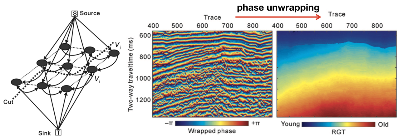
- We propose a robust phase unwrapping method to compute a relative geologic time volume from a 3D seismic instantaneous phase volume. We provide a convenient way to incorporate interpreted horizons and unconformities into our phase unwrapping method to obtain more reliable results in cases complicated by noise, faults, and unconformities. Using a computed RGT volume, we further automatically generate a 3D seismic Wheeler volume.
- Wu, X. and G. Zhong, 2012, Generating a relative geologic time volume by improved 3D graph-cut-based phase unwrapping method with horizon and unconformity constraints. Geophysics, 77 (4), O21-O34. [PDF]